You are here: Home > Network List > TA - USArray Transportable Network (new EarthScope stations) Stations List
> Station Z41A Richland Creek Farm, El Dorado, AR, USA > Earthquake Result Viewer
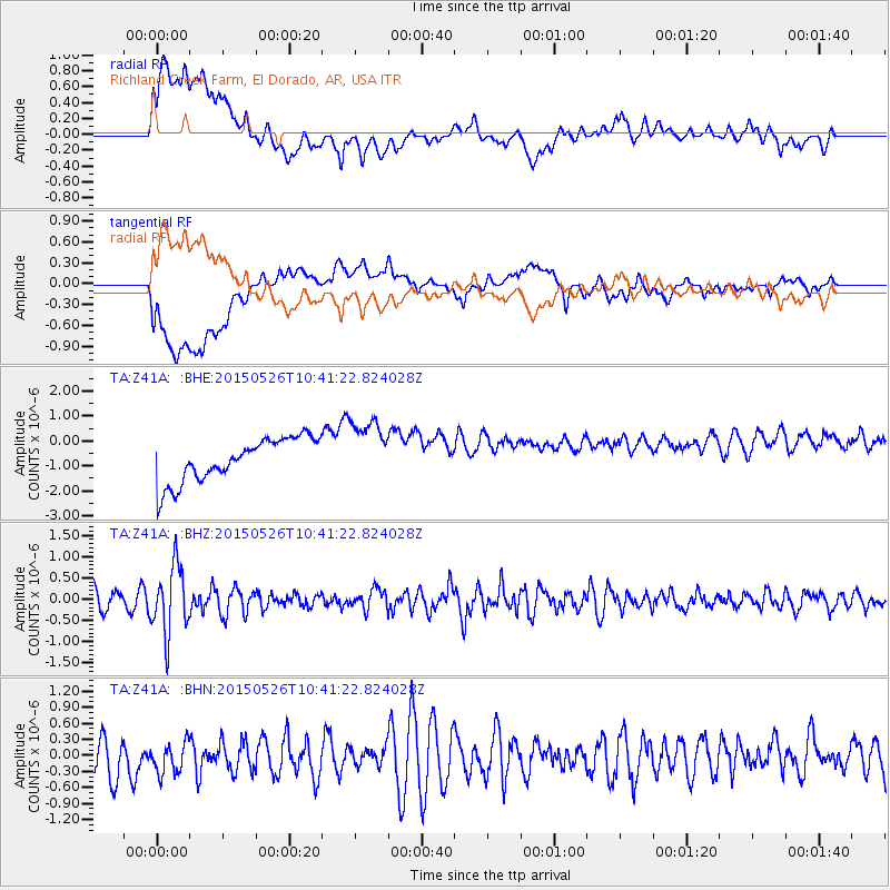
Z41A Richland Creek Farm, El Dorado, AR, USA - Earthquake Result Viewer
*The percent match for this event was below the threshold and hence no stack was calculated.
| Earthquake location: |
Northern Chile |
| Earthquake latitude/longitude: |
-22.1/-68.4 |
| Earthquake time(UTC): |
2015/05/26 (146) 10:32:01 GMT |
| Earthquake Depth: |
115 km |
| Earthquake Magnitude: |
5.7 MB |
| Earthquake Catalog/Contributor: |
NEIC PDE/NEIC COMCAT |
|
| Network: |
TA USArray Transportable Network (new EarthScope stations) |
| Station: |
Z41A Richland Creek Farm, El Dorado, AR, USA |
| Lat/Lon: |
33.26 N/92.80 W |
| Elevation: |
62 m |
|
| Distance: |
59.7 deg |
| Az: |
336.404 deg |
| Baz: |
153.695 deg |
| Ray Param: |
$rayparam |
*The percent match for this event was below the threshold and hence was not used in the summary stack. |
|
| Radial Match: |
35.45581 % |
| Radial Bump: |
400 |
| Transverse Match: |
34.18865 % |
| Transverse Bump: |
400 |
| SOD ConfigId: |
7422571 |
| Insert Time: |
2019-04-19 02:01:26.860 +0000 |
| GWidth: |
2.5 |
| Max Bumps: |
400 |
| Tol: |
0.001 |
|
Signal To Noise
| Channel | StoN | STA | LTA |
| TA:Z41A: :BHZ:20150526T10:41:22.824028Z | 4.468278 | 7.908857E-7 | 1.7700012E-7 |
| TA:Z41A: :BHN:20150526T10:41:22.824028Z | 0.6801821 | 3.317609E-7 | 4.87753E-7 |
| TA:Z41A: :BHE:20150526T10:41:22.824028Z | 1.4171877 | 1.1885429E-6 | 8.38663E-7 |
| Arrivals |
| Ps | |
| PpPs | |
| PsPs/PpSs | |


