You are here: Home > Network List > UW - Pacific Northwest Regional Seismic Network Stations List
> Station UMAT Pilot Rock, OR, USA > Earthquake Result Viewer
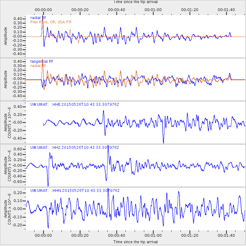
UMAT Pilot Rock, OR, USA - Earthquake Result Viewer
*The percent match for this event was below the threshold and hence no stack was calculated.
| Earthquake location: |
Northern Chile |
| Earthquake latitude/longitude: |
-22.1/-68.4 |
| Earthquake time(UTC): |
2015/05/26 (146) 10:32:01 GMT |
| Earthquake Depth: |
115 km |
| Earthquake Magnitude: |
5.7 MB |
| Earthquake Catalog/Contributor: |
NEIC PDE/NEIC COMCAT |
|
| Network: |
UW Pacific Northwest Regional Seismic Network |
| Station: |
UMAT Pilot Rock, OR, USA |
| Lat/Lon: |
45.29 N/118.96 W |
| Elevation: |
1318 m |
|
| Distance: |
81.3 deg |
| Az: |
326.547 deg |
| Baz: |
133.581 deg |
| Ray Param: |
$rayparam |
*The percent match for this event was below the threshold and hence was not used in the summary stack. |
|
| Radial Match: |
70.15677 % |
| Radial Bump: |
400 |
| Transverse Match: |
62.318542 % |
| Transverse Bump: |
400 |
| SOD ConfigId: |
7422571 |
| Insert Time: |
2019-04-19 02:02:33.279 +0000 |
| GWidth: |
2.5 |
| Max Bumps: |
400 |
| Tol: |
0.001 |
|
Signal To Noise
| Channel | StoN | STA | LTA |
| UW:UMAT: :HHZ:20150526T10:43:33.307976Z | 4.6940885 | 2.954686E-7 | 6.294483E-8 |
| UW:UMAT: :HHN:20150526T10:43:33.307976Z | 1.3259991 | 7.552251E-8 | 5.6955173E-8 |
| UW:UMAT: :HHE:20150526T10:43:33.307976Z | 3.1734493 | 1.3737748E-7 | 4.3289646E-8 |
| Arrivals |
| Ps | |
| PpPs | |
| PsPs/PpSs | |


