You are here: Home > Network List > CB - China National Seismic Network Stations List
> Station CN2 Changchun,Jilin Province > Earthquake Result Viewer
CN2 Changchun,Jilin Province - Earthquake Result Viewer
| Earthquake location: |
Irian Jaya Region, Indonesia |
| Earthquake latitude/longitude: |
-0.4/135.8 |
| Earthquake time(UTC): |
2015/05/26 (146) 16:42:36 GMT |
| Earthquake Depth: |
45 km |
| Earthquake Magnitude: |
5.8 MW, 5.3 mb, 5.5 MS |
| Earthquake Catalog/Contributor: |
ISC/ISC |
|
| Network: |
CB China National Seismic Network |
| Station: |
CN2 Changchun,Jilin Province |
| Lat/Lon: |
43.48 N/125.26 E |
| Elevation: |
223 m |
|
| Distance: |
44.7 deg |
| Az: |
349.124 deg |
| Baz: |
164.977 deg |
| Ray Param: |
0.07163158 |
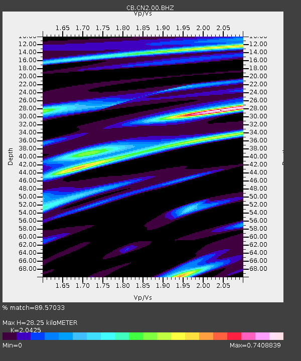
| Estimated Moho Depth: |
28.25 km |
| Estimated Crust Vp/Vs: |
2.04 |
| Assumed Crust Vp: |
6.459 km/s |
| Estimated Crust Vs: |
3.163 km/s |
| Estimated Crust Poisson's Ratio: |
0.34 |
|
| Radial Match: |
89.57033 % |
| Radial Bump: |
287 |
| Transverse Match: |
84.500565 % |
| Transverse Bump: |
386 |
| SOD ConfigId: |
7422571 |
| Insert Time: |
2019-04-19 02:06:12.831 +0000 |
| GWidth: |
2.5 |
| Max Bumps: |
400 |
| Tol: |
0.001 |
|

Signal To Noise
| Channel | StoN | STA | LTA |
| CB:CN2:00:BHZ:20150526T16:50:15.01001Z | 5.562839 | 4.332884E-7 | 7.7889794E-8 |
| CB:CN2:00:BHN:20150526T16:50:15.01001Z | 3.6076086 | 1.8809112E-7 | 5.2137345E-8 |
| CB:CN2:00:BHE:20150526T16:50:15.01001Z | 1.2730086 | 5.6911286E-8 | 4.470613E-8 |
| Arrivals |
| Ps | 4.8 SECOND |
| PpPs | 13 SECOND |
| PsPs/PpSs | 17 SECOND |


