You are here: Home > Network List > CB - China National Seismic Network Stations List
> Station GOM Geermu,Qinghai Province > Earthquake Result Viewer
GOM Geermu,Qinghai Province - Earthquake Result Viewer
| Earthquake location: |
Irian Jaya Region, Indonesia |
| Earthquake latitude/longitude: |
-0.4/135.8 |
| Earthquake time(UTC): |
2015/05/26 (146) 16:42:36 GMT |
| Earthquake Depth: |
45 km |
| Earthquake Magnitude: |
5.8 MW, 5.3 mb, 5.5 MS |
| Earthquake Catalog/Contributor: |
ISC/ISC |
|
| Network: |
CB China National Seismic Network |
| Station: |
GOM Geermu,Qinghai Province |
| Lat/Lon: |
36.20 N/94.81 E |
| Elevation: |
3121 m |
|
| Distance: |
52.7 deg |
| Az: |
318.181 deg |
| Baz: |
124.48 deg |
| Ray Param: |
0.06650748 |
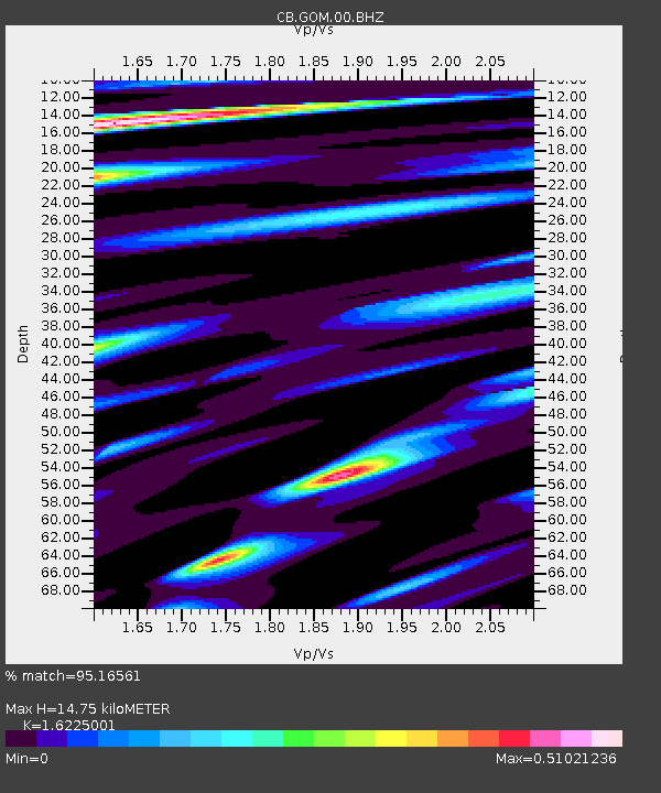
| Estimated Moho Depth: |
14.75 km |
| Estimated Crust Vp/Vs: |
1.62 |
| Assumed Crust Vp: |
6.385 km/s |
| Estimated Crust Vs: |
3.935 km/s |
| Estimated Crust Poisson's Ratio: |
0.19 |
|
| Radial Match: |
95.16561 % |
| Radial Bump: |
286 |
| Transverse Match: |
79.40088 % |
| Transverse Bump: |
400 |
| SOD ConfigId: |
7422571 |
| Insert Time: |
2019-04-19 02:06:12.866 +0000 |
| GWidth: |
2.5 |
| Max Bumps: |
400 |
| Tol: |
0.001 |
|

Signal To Noise
| Channel | StoN | STA | LTA |
| CB:GOM:00:BHZ:20150526T16:51:15.900024Z | 4.2718863 | 2.124255E-7 | 4.9726395E-8 |
| CB:GOM:00:BHN:20150526T16:51:15.900024Z | 0.77837354 | 3.239393E-8 | 4.1617458E-8 |
| CB:GOM:00:BHE:20150526T16:51:15.900024Z | 3.3031788 | 7.869122E-8 | 2.3822876E-8 |
| Arrivals |
| Ps | 1.5 SECOND |
| PpPs | 5.7 SECOND |
| PsPs/PpSs | 7.2 SECOND |


