You are here: Home > Network List > TA - USArray Transportable Network (new EarthScope stations) Stations List
> Station I23K Minto, Yukon-Koyukuk, AK, USA > Earthquake Result Viewer
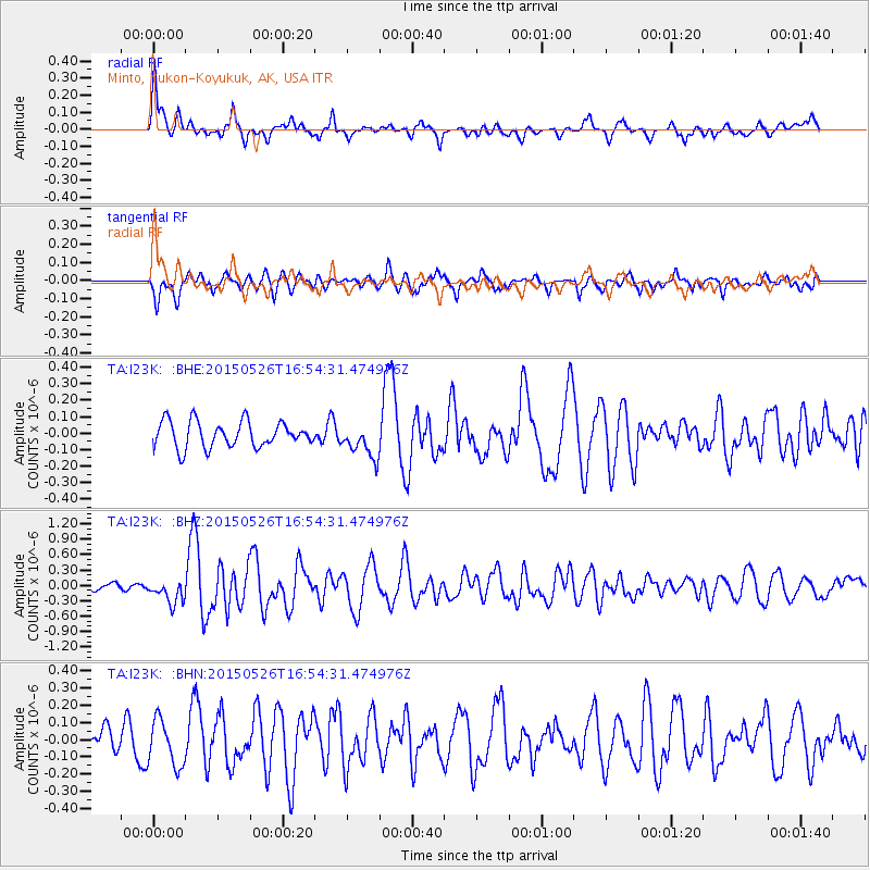
I23K Minto, Yukon-Koyukuk, AK, USA - Earthquake Result Viewer
*The percent match for this event was below the threshold and hence no stack was calculated.
| Earthquake location: |
Irian Jaya Region, Indonesia |
| Earthquake latitude/longitude: |
-0.4/135.8 |
| Earthquake time(UTC): |
2015/05/26 (146) 16:42:36 GMT |
| Earthquake Depth: |
45 km |
| Earthquake Magnitude: |
5.8 MW, 5.3 mb, 5.5 MS |
| Earthquake Catalog/Contributor: |
ISC/ISC |
|
| Network: |
TA USArray Transportable Network (new EarthScope stations) |
| Station: |
I23K Minto, Yukon-Koyukuk, AK, USA |
| Lat/Lon: |
65.15 N/149.36 W |
| Elevation: |
149 m |
|
| Distance: |
84.1 deg |
| Az: |
24.215 deg |
| Baz: |
256.054 deg |
| Ray Param: |
$rayparam |
*The percent match for this event was below the threshold and hence was not used in the summary stack. |
|
| Radial Match: |
78.70307 % |
| Radial Bump: |
376 |
| Transverse Match: |
62.50272 % |
| Transverse Bump: |
400 |
| SOD ConfigId: |
7422571 |
| Insert Time: |
2019-04-19 02:08:13.415 +0000 |
| GWidth: |
2.5 |
| Max Bumps: |
400 |
| Tol: |
0.001 |
|
Signal To Noise
| Channel | StoN | STA | LTA |
| TA:I23K: :BHZ:20150526T16:54:31.474976Z | 3.4159622 | 2.3019682E-7 | 6.738858E-8 |
| TA:I23K: :BHN:20150526T16:54:31.474976Z | 1.7326739 | 1.34894E-7 | 7.785307E-8 |
| TA:I23K: :BHE:20150526T16:54:31.474976Z | 1.3111163 | 1.020849E-7 | 7.7861046E-8 |
| Arrivals |
| Ps | |
| PpPs | |
| PsPs/PpSs | |


