You are here: Home > Network List > GS - US Geological Survey Networks Stations List
> Station DEC09 Decatur Surface Seismic Site, Decatur, IL, USA > Earthquake Result Viewer
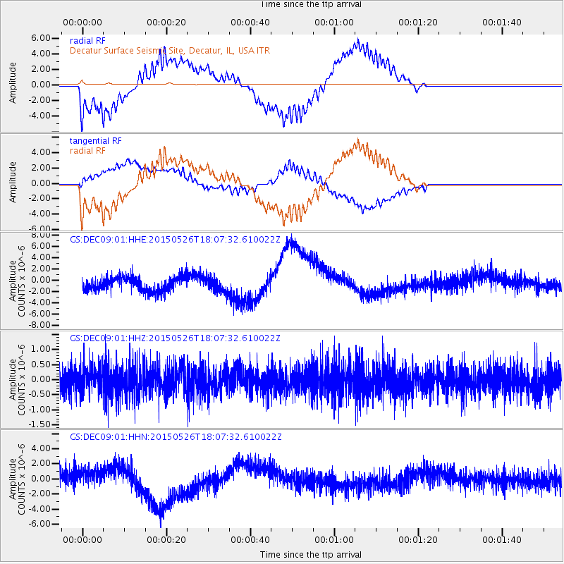
DEC09 Decatur Surface Seismic Site, Decatur, IL, USA - Earthquake Result Viewer
*The percent match for this event was below the threshold and hence no stack was calculated.
| Earthquake location: |
East Of Kuril Islands |
| Earthquake latitude/longitude: |
45.9/152.4 |
| Earthquake time(UTC): |
2015/05/26 (146) 17:56:06 GMT |
| Earthquake Depth: |
41 km |
| Earthquake Magnitude: |
4.3 mb, 4.0 mb |
| Earthquake Catalog/Contributor: |
ISC/ISC |
|
| Network: |
GS US Geological Survey Networks |
| Station: |
DEC09 Decatur Surface Seismic Site, Decatur, IL, USA |
| Lat/Lon: |
39.87 N/88.92 W |
| Elevation: |
207 m |
|
| Distance: |
78.5 deg |
| Az: |
43.555 deg |
| Baz: |
321.279 deg |
| Ray Param: |
$rayparam |
*The percent match for this event was below the threshold and hence was not used in the summary stack. |
|
| Radial Match: |
67.944305 % |
| Radial Bump: |
400 |
| Transverse Match: |
67.92305 % |
| Transverse Bump: |
400 |
| SOD ConfigId: |
7422571 |
| Insert Time: |
2019-04-19 02:12:09.679 +0000 |
| GWidth: |
2.5 |
| Max Bumps: |
400 |
| Tol: |
0.001 |
|
Signal To Noise
| Channel | StoN | STA | LTA |
| GS:DEC09:01:HHZ:20150526T18:07:32.610022Z | 0.94368654 | 4.2118887E-7 | 4.4632284E-7 |
| GS:DEC09:01:HHN:20150526T18:07:32.610022Z | 0.56721926 | 1.1468265E-6 | 2.02184E-6 |
| GS:DEC09:01:HHE:20150526T18:07:32.610022Z | 1.0275393 | 1.2910668E-6 | 1.2564648E-6 |
| Arrivals |
| Ps | |
| PpPs | |
| PsPs/PpSs | |


