You are here: Home > Network List > TA - USArray Transportable Network (new EarthScope stations) Stations List
> Station BGNE Belgrade, NE, USA > Earthquake Result Viewer
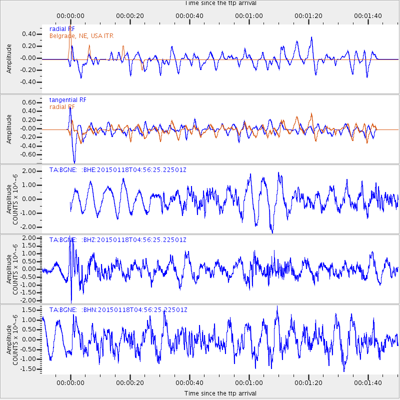
BGNE Belgrade, NE, USA - Earthquake Result Viewer
*The percent match for this event was below the threshold and hence no stack was calculated.
| Earthquake location: |
Rat Islands, Aleutian Islands |
| Earthquake latitude/longitude: |
51.9/179.6 |
| Earthquake time(UTC): |
2015/01/18 (018) 04:47:38 GMT |
| Earthquake Depth: |
106 km |
| Earthquake Magnitude: |
5.8 MB, 5.9 MB |
| Earthquake Catalog/Contributor: |
NEIC PDE/NEIC COMCAT |
|
| Network: |
TA USArray Transportable Network (new EarthScope stations) |
| Station: |
BGNE Belgrade, NE, USA |
| Lat/Lon: |
41.41 N/98.15 W |
| Elevation: |
573 m |
|
| Distance: |
54.6 deg |
| Az: |
66.189 deg |
| Baz: |
311.104 deg |
| Ray Param: |
$rayparam |
*The percent match for this event was below the threshold and hence was not used in the summary stack. |
|
| Radial Match: |
41.3276 % |
| Radial Bump: |
400 |
| Transverse Match: |
57.794346 % |
| Transverse Bump: |
400 |
| SOD ConfigId: |
837871 |
| Insert Time: |
2015-02-01 05:18:43.404 +0000 |
| GWidth: |
2.5 |
| Max Bumps: |
400 |
| Tol: |
0.001 |
|
Signal To Noise
| Channel | StoN | STA | LTA |
| TA:BGNE: :BHZ:20150118T04:56:25.22501Z | 4.2134438 | 1.0346428E-6 | 2.4555752E-7 |
| TA:BGNE: :BHN:20150118T04:56:25.22501Z | 1.0345272 | 6.2636417E-7 | 6.054594E-7 |
| TA:BGNE: :BHE:20150118T04:56:25.22501Z | 0.57248443 | 4.0954635E-7 | 7.153843E-7 |
| Arrivals |
| Ps | |
| PpPs | |
| PsPs/PpSs | |


