You are here: Home > Network List > G - GEOSCOPE Stations List
> Station MPG Montagne des Peres, French Guyana > Earthquake Result Viewer
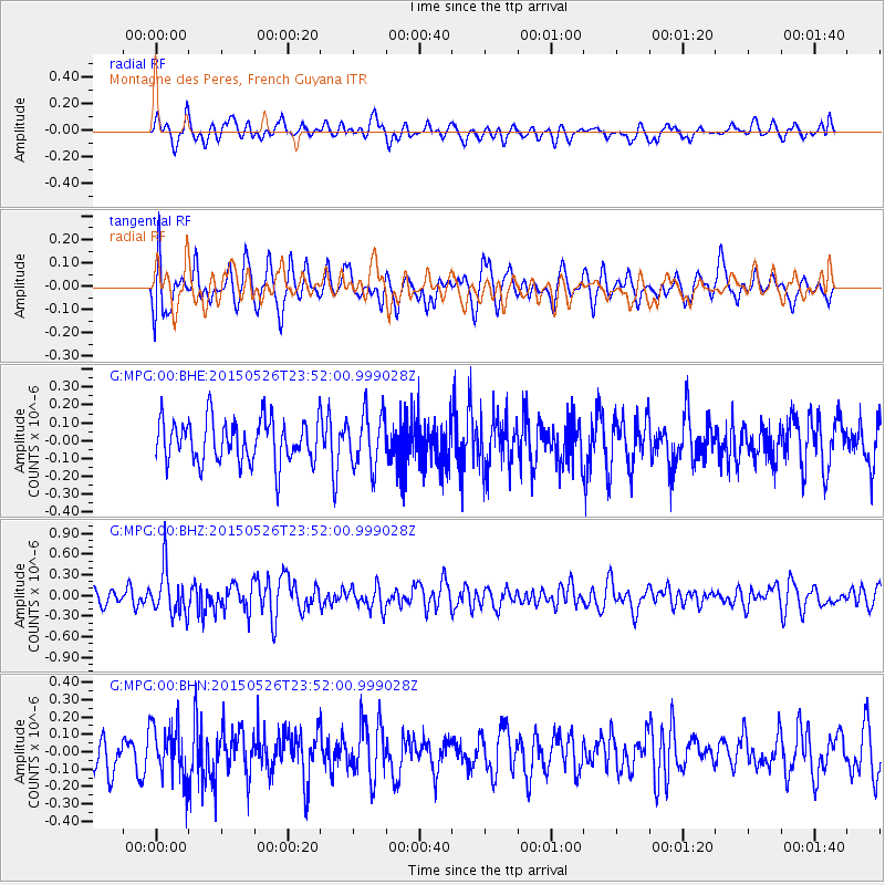
MPG Montagne des Peres, French Guyana - Earthquake Result Viewer
*The percent match for this event was below the threshold and hence no stack was calculated.
| Earthquake location: |
South Sandwich Islands Region |
| Earthquake latitude/longitude: |
-58.8/-25.2 |
| Earthquake time(UTC): |
2015/05/26 (146) 23:41:38 GMT |
| Earthquake Depth: |
18 km |
| Earthquake Magnitude: |
5.7 MW, 5.2 mb, 5.4 MS |
| Earthquake Catalog/Contributor: |
ISC/ISC |
|
| Network: |
G GEOSCOPE |
| Station: |
MPG Montagne des Peres, French Guyana |
| Lat/Lon: |
5.11 N/52.64 W |
| Elevation: |
147 m |
|
| Distance: |
67.4 deg |
| Az: |
330.219 deg |
| Baz: |
164.955 deg |
| Ray Param: |
$rayparam |
*The percent match for this event was below the threshold and hence was not used in the summary stack. |
|
| Radial Match: |
48.45809 % |
| Radial Bump: |
369 |
| Transverse Match: |
56.852283 % |
| Transverse Bump: |
400 |
| SOD ConfigId: |
7422571 |
| Insert Time: |
2019-04-19 02:20:52.834 +0000 |
| GWidth: |
2.5 |
| Max Bumps: |
400 |
| Tol: |
0.001 |
|
Signal To Noise
| Channel | StoN | STA | LTA |
| G:MPG:00:BHZ:20150526T23:52:00.999028Z | 2.5065439 | 3.317351E-7 | 1.3234761E-7 |
| G:MPG:00:BHN:20150526T23:52:00.999028Z | 1.3500258 | 1.5587472E-7 | 1.15460544E-7 |
| G:MPG:00:BHE:20150526T23:52:00.999028Z | 1.259851 | 1.5085028E-7 | 1.197366E-7 |
| Arrivals |
| Ps | |
| PpPs | |
| PsPs/PpSs | |


