You are here: Home > Network List > TA - USArray Transportable Network (new EarthScope stations) Stations List
> Station J04D Umpqua National Forest, Toketee, OR, USA > Earthquake Result Viewer
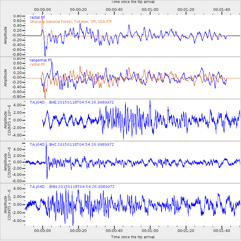
J04D Umpqua National Forest, Toketee, OR, USA - Earthquake Result Viewer
*The percent match for this event was below the threshold and hence no stack was calculated.
| Earthquake location: |
Rat Islands, Aleutian Islands |
| Earthquake latitude/longitude: |
51.9/179.6 |
| Earthquake time(UTC): |
2015/01/18 (018) 04:47:38 GMT |
| Earthquake Depth: |
106 km |
| Earthquake Magnitude: |
5.8 MB, 5.9 MB |
| Earthquake Catalog/Contributor: |
NEIC PDE/NEIC COMCAT |
|
| Network: |
TA USArray Transportable Network (new EarthScope stations) |
| Station: |
J04D Umpqua National Forest, Toketee, OR, USA |
| Lat/Lon: |
43.24 N/122.11 W |
| Elevation: |
1948 m |
|
| Distance: |
39.3 deg |
| Az: |
78.93 deg |
| Baz: |
303.695 deg |
| Ray Param: |
$rayparam |
*The percent match for this event was below the threshold and hence was not used in the summary stack. |
|
| Radial Match: |
59.142296 % |
| Radial Bump: |
400 |
| Transverse Match: |
51.996643 % |
| Transverse Bump: |
400 |
| SOD ConfigId: |
837871 |
| Insert Time: |
2015-02-01 05:20:14.527 +0000 |
| GWidth: |
2.5 |
| Max Bumps: |
400 |
| Tol: |
0.001 |
|
Signal To Noise
| Channel | StoN | STA | LTA |
| TA:J04D: :BHZ:20150118T04:54:26.998997Z | 4.18739 | 1.974326E-6 | 4.7149325E-7 |
| TA:J04D: :BHN:20150118T04:54:26.998997Z | 1.433514 | 1.2880681E-6 | 8.9853893E-7 |
| TA:J04D: :BHE:20150118T04:54:26.998997Z | 1.1878359 | 1.2364026E-6 | 1.0408867E-6 |
| Arrivals |
| Ps | |
| PpPs | |
| PsPs/PpSs | |


