You are here: Home > Network List > YQ13 - Study of Extension and Magmatism in Malawi and Tanzania Stations List
> Station LOSI Makongolosi,Tanzania > Earthquake Result Viewer
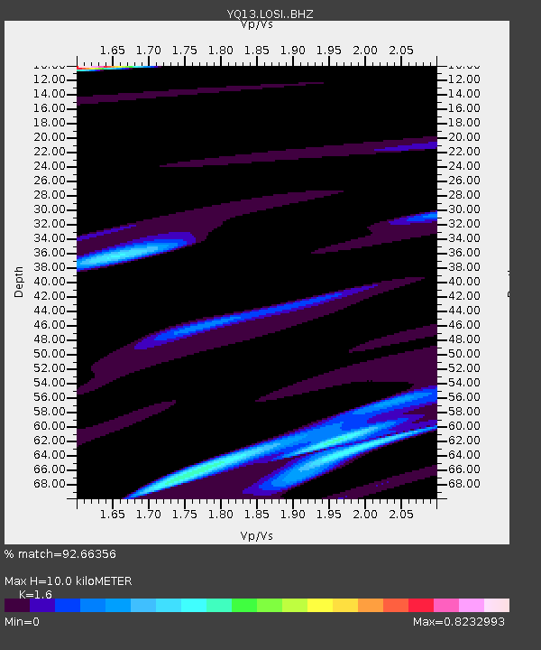
LOSI Makongolosi,Tanzania - Earthquake Result Viewer
| Earthquake location: |
South Sandwich Islands Region |
| Earthquake latitude/longitude: |
-58.7/-25.2 |
| Earthquake time(UTC): |
2015/05/26 (146) 23:51:29 GMT |
| Earthquake Depth: |
28 km |
| Earthquake Magnitude: |
5.6 MW, 5.3 mb, 5.2 MS |
| Earthquake Catalog/Contributor: |
ISC/ISC |
|
| Network: |
YQ Study of Extension and Magmatism in Malawi and Tanzania |
| Station: |
LOSI Makongolosi,Tanzania |
| Lat/Lon: |
8.39 S/33.17 E |
| Elevation: |
1233 m |
|
| Distance: |
66.7 deg |
| Az: |
66.44 deg |
| Baz: |
208.937 deg |
| Ray Param: |
0.057372004 |
| Estimated Moho Depth: |
10.0 km |
| Estimated Crust Vp/Vs: |
1.60 |
| Assumed Crust Vp: |
6.502 km/s |
| Estimated Crust Vs: |
4.063 km/s |
| Estimated Crust Poisson's Ratio: |
0.18 |
|
| Radial Match: |
92.66356 % |
| Radial Bump: |
400 |
| Transverse Match: |
61.453423 % |
| Transverse Bump: |
400 |
| SOD ConfigId: |
7422571 |
| Insert Time: |
2019-04-19 02:24:32.509 +0000 |
| GWidth: |
2.5 |
| Max Bumps: |
400 |
| Tol: |
0.001 |
|

Signal To Noise
| Channel | StoN | STA | LTA |
| YQ:LOSI: :BHZ:20150527T00:01:47.375Z | 0.7494266 | 1.8760662E-7 | 2.5033356E-7 |
| YQ:LOSI: :BHN:20150527T00:01:47.375Z | 1.9607881 | 3.4027778E-7 | 1.7354134E-7 |
| YQ:LOSI: :BHE:20150527T00:01:47.375Z | 2.9164562 | 3.735604E-7 | 1.280871E-7 |
| Arrivals |
| Ps | 1.0 SECOND |
| PpPs | 3.8 SECOND |
| PsPs/PpSs | 4.8 SECOND |


