You are here: Home > Network List > TA - USArray Transportable Network (new EarthScope stations) Stations List
> Station M04C Macdoel, CA, USA > Earthquake Result Viewer
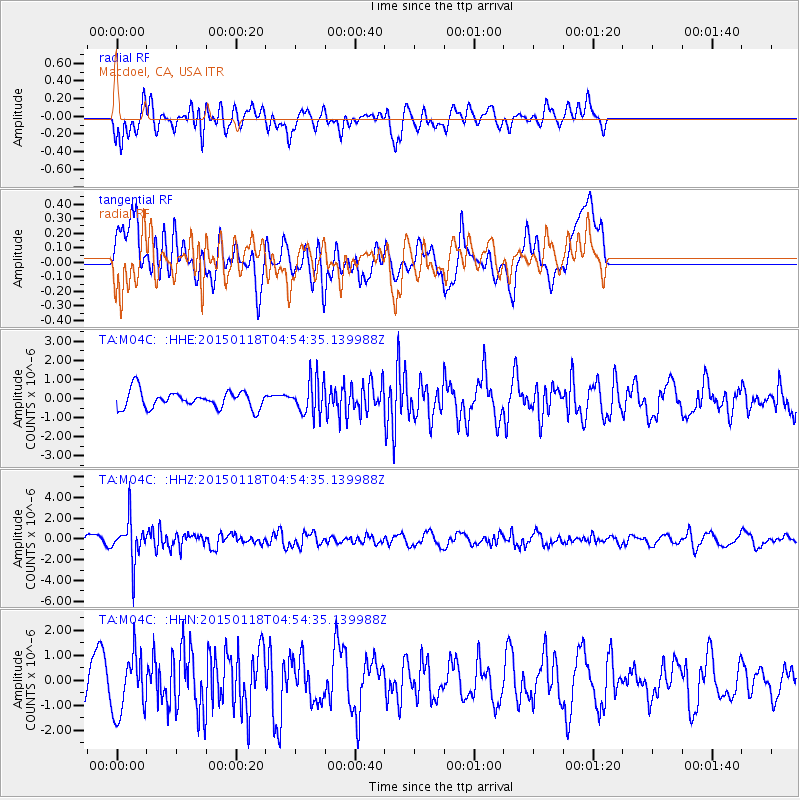
M04C Macdoel, CA, USA - Earthquake Result Viewer
*The percent match for this event was below the threshold and hence no stack was calculated.
| Earthquake location: |
Rat Islands, Aleutian Islands |
| Earthquake latitude/longitude: |
51.9/179.6 |
| Earthquake time(UTC): |
2015/01/18 (018) 04:47:38 GMT |
| Earthquake Depth: |
106 km |
| Earthquake Magnitude: |
5.8 MB, 5.9 MB |
| Earthquake Catalog/Contributor: |
NEIC PDE/NEIC COMCAT |
|
| Network: |
TA USArray Transportable Network (new EarthScope stations) |
| Station: |
M04C Macdoel, CA, USA |
| Lat/Lon: |
41.78 N/121.84 W |
| Elevation: |
1391 m |
|
| Distance: |
40.3 deg |
| Az: |
80.63 deg |
| Baz: |
305.182 deg |
| Ray Param: |
$rayparam |
*The percent match for this event was below the threshold and hence was not used in the summary stack. |
|
| Radial Match: |
58.77748 % |
| Radial Bump: |
400 |
| Transverse Match: |
50.522774 % |
| Transverse Bump: |
400 |
| SOD ConfigId: |
837871 |
| Insert Time: |
2015-02-01 05:21:08.724 +0000 |
| GWidth: |
2.5 |
| Max Bumps: |
400 |
| Tol: |
0.001 |
|
Signal To Noise
| Channel | StoN | STA | LTA |
| TA:M04C: :HHZ:20150118T04:54:35.139988Z | 5.274074 | 1.9803779E-6 | 3.75493E-7 |
| TA:M04C: :HHN:20150118T04:54:35.139988Z | 2.3426306 | 1.1735309E-6 | 5.0094576E-7 |
| TA:M04C: :HHE:20150118T04:54:35.139988Z | 1.9688108 | 8.8861015E-7 | 4.513436E-7 |
| Arrivals |
| Ps | |
| PpPs | |
| PsPs/PpSs | |


