You are here: Home > Network List > IU - Global Seismograph Network (GSN - IRIS/USGS) Stations List
> Station XMAS Kiritimati Island, Republic of Kiribati > Earthquake Result Viewer
XMAS Kiritimati Island, Republic of Kiribati - Earthquake Result Viewer
| Earthquake location: |
Northeast Of Taiwan |
| Earthquake latitude/longitude: |
25.3/123.4 |
| Earthquake time(UTC): |
2005/10/15 (288) 15:51:07 GMT |
| Earthquake Depth: |
183 km |
| Earthquake Magnitude: |
6.2 MB, 6.5 MW, 6.5 MW |
| Earthquake Catalog/Contributor: |
WHDF/NEIC |
|
| Network: |
IU Global Seismograph Network (GSN - IRIS/USGS) |
| Station: |
XMAS Kiritimati Island, Republic of Kiribati |
| Lat/Lon: |
2.04 N/157.45 W |
| Elevation: |
2.0 m |
|
| Distance: |
79.4 deg |
| Az: |
92.775 deg |
| Baz: |
295.239 deg |
| Ray Param: |
0.0485573 |
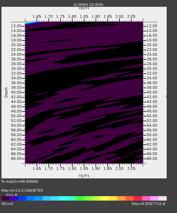
| Estimated Moho Depth: |
10.0 km |
| Estimated Crust Vp/Vs: |
1.60 |
| Assumed Crust Vp: |
4.802 km/s |
| Estimated Crust Vs: |
3.001 km/s |
| Estimated Crust Poisson's Ratio: |
0.18 |
|
| Radial Match: |
99.99999 % |
| Radial Bump: |
2 |
| Transverse Match: |
100.0 % |
| Transverse Bump: |
2 |
| SOD ConfigId: |
2564 |
| Insert Time: |
2010-03-02 15:46:00.501 +0000 |
| GWidth: |
2.5 |
| Max Bumps: |
400 |
| Tol: |
0.001 |
|
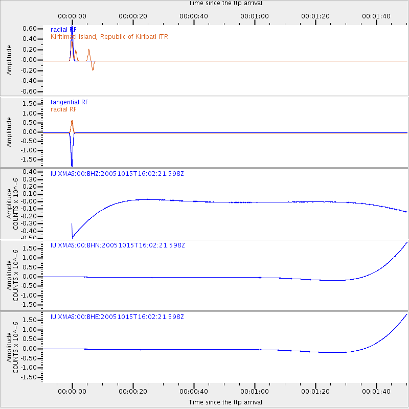
Signal To Noise
| Channel | StoN | STA | LTA |
| IU:XMAS:00:BHN:20051015T16:02:21.598Z | 0.9115365 | 1.3979312E-7 | 1.5335986E-7 |
| IU:XMAS:00:BHE:20051015T16:02:21.598Z | 0.91204536 | 1.3977446E-7 | 1.5325384E-7 |
| IU:XMAS:00:BHZ:20051015T16:02:21.598Z | 0.91192037 | 1.392502E-7 | 1.5269995E-7 |
| Arrivals |
| Ps | 1.3 SECOND |
| PpPs | 5.3 SECOND |
| PsPs/PpSs | 6.6 SECOND |


