You are here: Home > Network List > IU - Global Seismograph Network (GSN - IRIS/USGS) Stations List
> Station XMAS Kiritimati Island, Republic of Kiribati > Earthquake Result Viewer
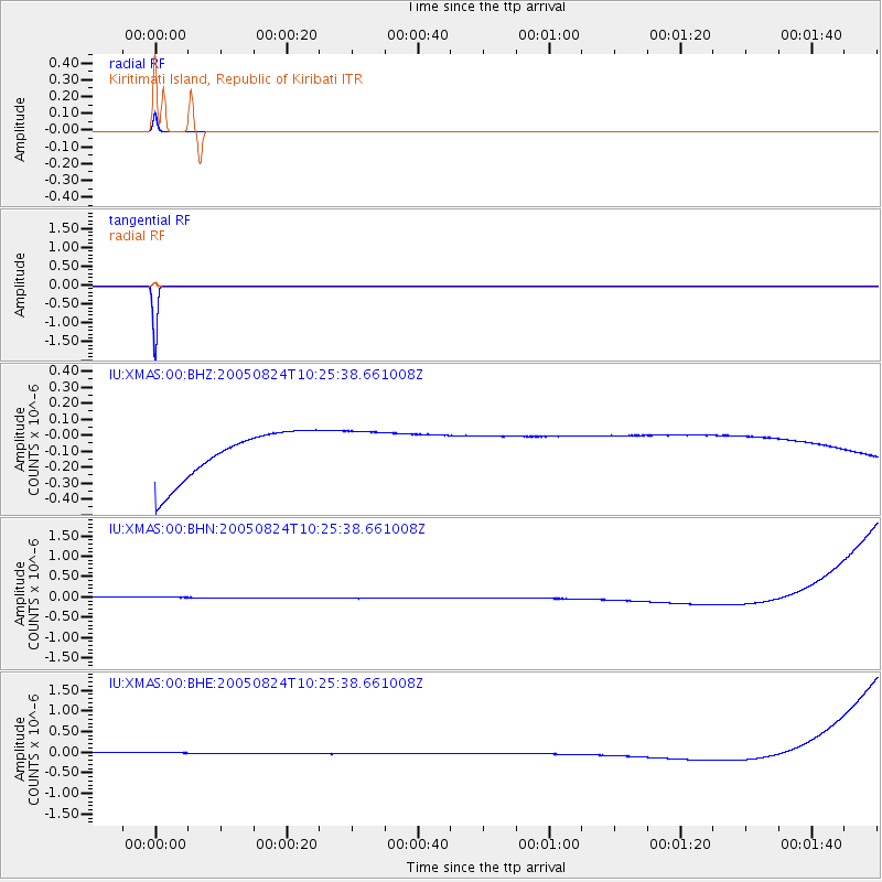
XMAS Kiritimati Island, Republic of Kiribati - Earthquake Result Viewer

| Earthquake location: |
Near East Coast Of Honshu, Japan |
| Earthquake latitude/longitude: |
38.6/143.0 |
| Earthquake time(UTC): |
2005/08/24 (236) 10:15:28 GMT |
| Earthquake Depth: |
10 km |
| Earthquake Magnitude: |
6.0 MB, 5.6 MS, 6.2 MW |
| Earthquake Catalog/Contributor: |
WHDF/NEIC |
|
| Network: |
IU Global Seismograph Network (GSN - IRIS/USGS) |
| Station: |
XMAS Kiritimati Island, Republic of Kiribati |
| Lat/Lon: |
2.04 N/157.45 W |
| Elevation: |
2.0 m |
|
| Distance: |
65.2 deg |
| Az: |
108.39 deg |
| Baz: |
311.894 deg |
| Ray Param: |
0.058402807 |
| Estimated Moho Depth: |
10.0 km |
| Estimated Crust Vp/Vs: |
1.60 |
| Assumed Crust Vp: |
4.802 km/s |
| Estimated Crust Vs: |
3.001 km/s |
| Estimated Crust Poisson's Ratio: |
0.18 |
|
| Radial Match: |
99.99999 % |
| Radial Bump: |
2 |
| Transverse Match: |
100.00001 % |
| Transverse Bump: |
2 |
| SOD ConfigId: |
2564 |
| Insert Time: |
2010-03-02 15:46:12.488 +0000 |
| GWidth: |
2.5 |
| Max Bumps: |
400 |
| Tol: |
0.001 |
|
Signal To Noise
| Channel | StoN | STA | LTA |
| IU:XMAS:00:BHN:20050824T10:25:38.661008Z | 0.9138538 | 1.395029E-7 | 1.5265341E-7 |
| IU:XMAS:00:BHE:20050824T10:25:38.661008Z | 0.91397935 | 1.3949864E-7 | 1.5262778E-7 |
| IU:XMAS:00:BHZ:20050824T10:25:38.661008Z | 0.9138986 | 1.3912236E-7 | 1.5222955E-7 |
| Arrivals |
| Ps | 1.3 SECOND |
| PpPs | 5.3 SECOND |
| PsPs/PpSs | 6.6 SECOND |


