You are here: Home > Network List > 7A - Mid-Atlantic Geophysical Integrative Collaboration Stations List
> Station CABN Riverton, West Virginia USA > Earthquake Result Viewer
CABN Riverton, West Virginia USA - Earthquake Result Viewer
| Earthquake location: |
Alaska Peninsula |
| Earthquake latitude/longitude: |
56.7/-156.5 |
| Earthquake time(UTC): |
2015/05/29 (149) 07:00:08 GMT |
| Earthquake Depth: |
62 km |
| Earthquake Magnitude: |
6.8 MWP, 6.8 MI |
| Earthquake Catalog/Contributor: |
NEIC PDE/NEIC COMCAT |
|
| Network: |
7A Mid-Atlantic Geophysical Integrative Collaboration |
| Station: |
CABN Riverton, West Virginia USA |
| Lat/Lon: |
38.72 N/79.44 W |
| Elevation: |
910 m |
|
| Distance: |
52.0 deg |
| Az: |
75.45 deg |
| Baz: |
316.95 deg |
| Ray Param: |
0.06688937 |
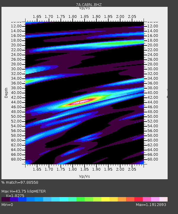
| Estimated Moho Depth: |
43.75 km |
| Estimated Crust Vp/Vs: |
1.83 |
| Assumed Crust Vp: |
6.159 km/s |
| Estimated Crust Vs: |
3.37 km/s |
| Estimated Crust Poisson's Ratio: |
0.29 |
|
| Radial Match: |
97.88558 % |
| Radial Bump: |
318 |
| Transverse Match: |
89.4693 % |
| Transverse Bump: |
400 |
| SOD ConfigId: |
7422571 |
| Insert Time: |
2019-04-19 02:33:27.972 +0000 |
| GWidth: |
2.5 |
| Max Bumps: |
400 |
| Tol: |
0.001 |
|

Signal To Noise
| Channel | StoN | STA | LTA |
| 7A:CABN: :BHZ:20150529T07:08:40.564988Z | 39.54339 | 2.9830903E-6 | 7.5438415E-8 |
| 7A:CABN: :BHN:20150529T07:08:40.564988Z | 16.207048 | 1.3730643E-6 | 8.472019E-8 |
| 7A:CABN: :BHE:20150529T07:08:40.564988Z | 14.642383 | 1.2270445E-6 | 8.380088E-8 |
| Arrivals |
| Ps | 6.2 SECOND |
| PpPs | 19 SECOND |
| PsPs/PpSs | 25 SECOND |


