You are here: Home > Network List > 7A - Mid-Atlantic Geophysical Integrative Collaboration Stations List
> Station LBDL Montpelier, Virginia USA > Earthquake Result Viewer
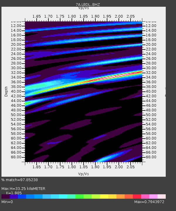
LBDL Montpelier, Virginia USA - Earthquake Result Viewer
| Earthquake location: |
Alaska Peninsula |
| Earthquake latitude/longitude: |
56.7/-156.5 |
| Earthquake time(UTC): |
2015/05/29 (149) 07:00:08 GMT |
| Earthquake Depth: |
62 km |
| Earthquake Magnitude: |
6.8 MWP, 6.8 MI |
| Earthquake Catalog/Contributor: |
NEIC PDE/NEIC COMCAT |
|
| Network: |
7A Mid-Atlantic Geophysical Integrative Collaboration |
| Station: |
LBDL Montpelier, Virginia USA |
| Lat/Lon: |
37.80 N/77.64 W |
| Elevation: |
48 m |
|
| Distance: |
53.6 deg |
| Az: |
74.922 deg |
| Baz: |
317.742 deg |
| Ray Param: |
0.06581328 |
| Estimated Moho Depth: |
33.25 km |
| Estimated Crust Vp/Vs: |
1.99 |
| Assumed Crust Vp: |
6.565 km/s |
| Estimated Crust Vs: |
3.307 km/s |
| Estimated Crust Poisson's Ratio: |
0.33 |
|
| Radial Match: |
97.85238 % |
| Radial Bump: |
320 |
| Transverse Match: |
93.67038 % |
| Transverse Bump: |
400 |
| SOD ConfigId: |
7422571 |
| Insert Time: |
2019-04-19 02:33:32.337 +0000 |
| GWidth: |
2.5 |
| Max Bumps: |
400 |
| Tol: |
0.001 |
|

Signal To Noise
| Channel | StoN | STA | LTA |
| 7A:LBDL: :BHZ:20150529T07:08:52.609971Z | 41.93409 | 3.1848592E-6 | 7.5949174E-8 |
| 7A:LBDL: :BHN:20150529T07:08:52.609971Z | 28.3224 | 1.3152212E-6 | 4.6437492E-8 |
| 7A:LBDL: :BHE:20150529T07:08:52.609971Z | 17.619818 | 8.316408E-7 | 4.7199173E-8 |
| Arrivals |
| Ps | 5.2 SECOND |
| PpPs | 14 SECOND |
| PsPs/PpSs | 20 SECOND |


