You are here: Home > Network List > 7A - Mid-Atlantic Geophysical Integrative Collaboration Stations List
> Station JSPR Franklin, West Virginia USA > Earthquake Result Viewer
JSPR Franklin, West Virginia USA - Earthquake Result Viewer
| Earthquake location: |
Alaska Peninsula |
| Earthquake latitude/longitude: |
56.7/-156.5 |
| Earthquake time(UTC): |
2015/05/29 (149) 07:00:08 GMT |
| Earthquake Depth: |
62 km |
| Earthquake Magnitude: |
6.8 MWP, 6.8 MI |
| Earthquake Catalog/Contributor: |
NEIC PDE/NEIC COMCAT |
|
| Network: |
7A Mid-Atlantic Geophysical Integrative Collaboration |
| Station: |
JSPR Franklin, West Virginia USA |
| Lat/Lon: |
38.64 N/79.33 W |
| Elevation: |
527 m |
|
| Distance: |
52.1 deg |
| Az: |
75.443 deg |
| Baz: |
317.013 deg |
| Ray Param: |
0.06681374 |
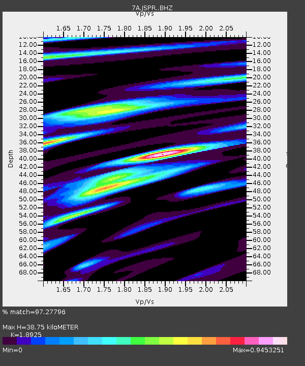
| Estimated Moho Depth: |
38.75 km |
| Estimated Crust Vp/Vs: |
1.89 |
| Assumed Crust Vp: |
6.159 km/s |
| Estimated Crust Vs: |
3.254 km/s |
| Estimated Crust Poisson's Ratio: |
0.31 |
|
| Radial Match: |
97.27796 % |
| Radial Bump: |
400 |
| Transverse Match: |
90.97094 % |
| Transverse Bump: |
400 |
| SOD ConfigId: |
7422571 |
| Insert Time: |
2019-04-19 02:33:32.743 +0000 |
| GWidth: |
2.5 |
| Max Bumps: |
400 |
| Tol: |
0.001 |
|

Signal To Noise
| Channel | StoN | STA | LTA |
| 7A:JSPR: :BHZ:20150529T07:08:41.465012Z | 48.53638 | 2.6142416E-6 | 5.3861488E-8 |
| 7A:JSPR: :BHN:20150529T07:08:41.465012Z | 21.349724 | 1.286042E-6 | 6.023694E-8 |
| 7A:JSPR: :BHE:20150529T07:08:41.465012Z | 11.483802 | 8.732541E-7 | 7.604225E-8 |
| Arrivals |
| Ps | 5.9 SECOND |
| PpPs | 17 SECOND |
| PsPs/PpSs | 23 SECOND |


