You are here: Home > Network List > TA - USArray Transportable Network (new EarthScope stations) Stations List
> Station TUL1 Leonard, OK, USA > Earthquake Result Viewer
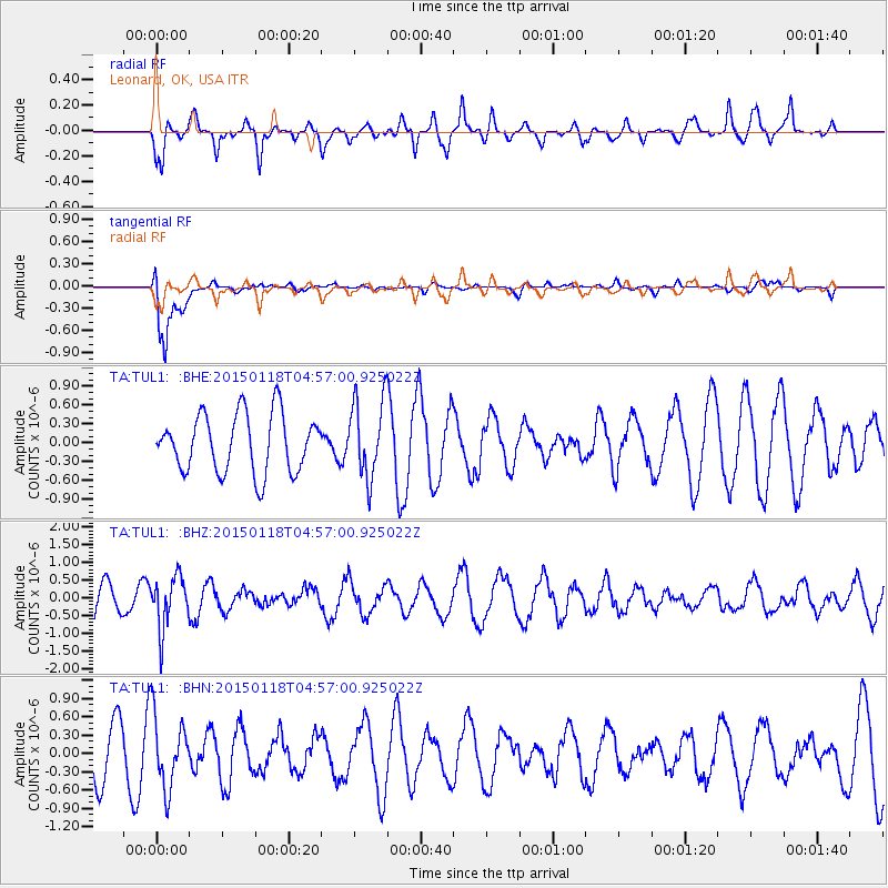
TUL1 Leonard, OK, USA - Earthquake Result Viewer
*The percent match for this event was below the threshold and hence no stack was calculated.
| Earthquake location: |
Rat Islands, Aleutian Islands |
| Earthquake latitude/longitude: |
51.9/179.6 |
| Earthquake time(UTC): |
2015/01/18 (018) 04:47:38 GMT |
| Earthquake Depth: |
106 km |
| Earthquake Magnitude: |
5.8 MB, 5.9 MB |
| Earthquake Catalog/Contributor: |
NEIC PDE/NEIC COMCAT |
|
| Network: |
TA USArray Transportable Network (new EarthScope stations) |
| Station: |
TUL1 Leonard, OK, USA |
| Lat/Lon: |
35.91 N/95.79 W |
| Elevation: |
256 m |
|
| Distance: |
59.6 deg |
| Az: |
69.497 deg |
| Baz: |
314.372 deg |
| Ray Param: |
$rayparam |
*The percent match for this event was below the threshold and hence was not used in the summary stack. |
|
| Radial Match: |
59.633144 % |
| Radial Bump: |
400 |
| Transverse Match: |
84.11945 % |
| Transverse Bump: |
400 |
| SOD ConfigId: |
837871 |
| Insert Time: |
2015-02-01 05:22:45.767 +0000 |
| GWidth: |
2.5 |
| Max Bumps: |
400 |
| Tol: |
0.001 |
|
Signal To Noise
| Channel | StoN | STA | LTA |
| TA:TUL1: :BHZ:20150118T04:57:00.925022Z | 1.3190651 | 7.22335E-7 | 5.4761136E-7 |
| TA:TUL1: :BHN:20150118T04:57:00.925022Z | 1.1770205 | 5.9588893E-7 | 5.06269E-7 |
| TA:TUL1: :BHE:20150118T04:57:00.925022Z | 1.3489023 | 6.197583E-7 | 4.594538E-7 |
| Arrivals |
| Ps | |
| PpPs | |
| PsPs/PpSs | |


