You are here: Home > Network List > 7A - Mid-Atlantic Geophysical Integrative Collaboration Stations List
> Station PVGR Lower Salem, Ohio USA > Earthquake Result Viewer
PVGR Lower Salem, Ohio USA - Earthquake Result Viewer
| Earthquake location: |
Alaska Peninsula |
| Earthquake latitude/longitude: |
56.7/-156.5 |
| Earthquake time(UTC): |
2015/05/29 (149) 07:00:08 GMT |
| Earthquake Depth: |
62 km |
| Earthquake Magnitude: |
6.8 MWP, 6.8 MI |
| Earthquake Catalog/Contributor: |
NEIC PDE/NEIC COMCAT |
|
| Network: |
7A Mid-Atlantic Geophysical Integrative Collaboration |
| Station: |
PVGR Lower Salem, Ohio USA |
| Lat/Lon: |
39.57 N/81.38 W |
| Elevation: |
0.0 m |
|
| Distance: |
50.3 deg |
| Az: |
76.106 deg |
| Baz: |
316.141 deg |
| Ray Param: |
0.06795804 |
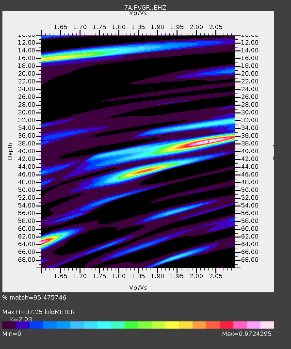
| Estimated Moho Depth: |
37.25 km |
| Estimated Crust Vp/Vs: |
2.03 |
| Assumed Crust Vp: |
6.207 km/s |
| Estimated Crust Vs: |
3.058 km/s |
| Estimated Crust Poisson's Ratio: |
0.34 |
|
| Radial Match: |
95.475746 % |
| Radial Bump: |
400 |
| Transverse Match: |
86.349495 % |
| Transverse Bump: |
400 |
| SOD ConfigId: |
7422571 |
| Insert Time: |
2019-04-19 02:33:37.172 +0000 |
| GWidth: |
2.5 |
| Max Bumps: |
400 |
| Tol: |
0.001 |
|

Signal To Noise
| Channel | StoN | STA | LTA |
| 7A:PVGR: :BHZ:20150529T07:08:28.219987Z | 32.69795 | 3.2228666E-6 | 9.85648E-8 |
| 7A:PVGR: :BHN:20150529T07:08:28.219987Z | 17.885258 | 1.4666856E-6 | 8.200528E-8 |
| 7A:PVGR: :BHE:20150529T07:08:28.219987Z | 12.3182 | 1.0937027E-6 | 8.8787544E-8 |
| Arrivals |
| Ps | 6.5 SECOND |
| PpPs | 17 SECOND |
| PsPs/PpSs | 24 SECOND |


