You are here: Home > Network List > 7A - Mid-Atlantic Geophysical Integrative Collaboration Stations List
> Station WIRE Hazelwood, West Virginia USA > Earthquake Result Viewer
WIRE Hazelwood, West Virginia USA - Earthquake Result Viewer
| Earthquake location: |
Alaska Peninsula |
| Earthquake latitude/longitude: |
56.7/-156.5 |
| Earthquake time(UTC): |
2015/05/29 (149) 07:00:08 GMT |
| Earthquake Depth: |
62 km |
| Earthquake Magnitude: |
6.8 MWP, 6.8 MI |
| Earthquake Catalog/Contributor: |
NEIC PDE/NEIC COMCAT |
|
| Network: |
7A Mid-Atlantic Geophysical Integrative Collaboration |
| Station: |
WIRE Hazelwood, West Virginia USA |
| Lat/Lon: |
38.85 N/79.84 W |
| Elevation: |
613 m |
|
| Distance: |
51.7 deg |
| Az: |
75.621 deg |
| Baz: |
316.809 deg |
| Ray Param: |
0.067091614 |
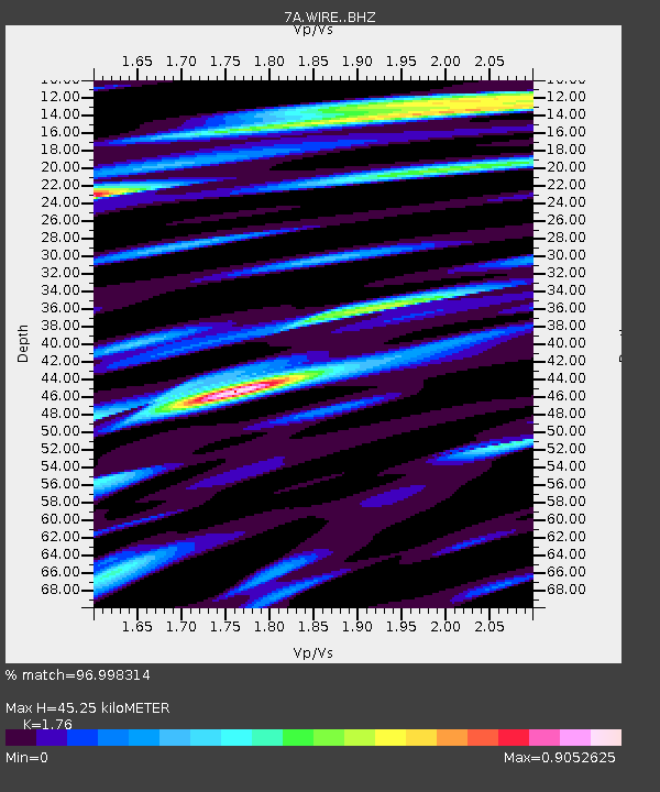
| Estimated Moho Depth: |
45.25 km |
| Estimated Crust Vp/Vs: |
1.76 |
| Assumed Crust Vp: |
6.159 km/s |
| Estimated Crust Vs: |
3.499 km/s |
| Estimated Crust Poisson's Ratio: |
0.26 |
|
| Radial Match: |
96.998314 % |
| Radial Bump: |
400 |
| Transverse Match: |
90.45169 % |
| Transverse Bump: |
400 |
| SOD ConfigId: |
7422571 |
| Insert Time: |
2019-04-19 02:33:38.551 +0000 |
| GWidth: |
2.5 |
| Max Bumps: |
400 |
| Tol: |
0.001 |
|

Signal To Noise
| Channel | StoN | STA | LTA |
| 7A:WIRE: :BHZ:20150529T07:08:38.280015Z | 57.234127 | 3.5523422E-6 | 6.206685E-8 |
| 7A:WIRE: :BHN:20150529T07:08:38.280015Z | 18.067148 | 1.2686896E-6 | 7.02208E-8 |
| 7A:WIRE: :BHE:20150529T07:08:38.280015Z | 16.735823 | 1.3433771E-6 | 8.026956E-8 |
| Arrivals |
| Ps | 5.9 SECOND |
| PpPs | 19 SECOND |
| PsPs/PpSs | 25 SECOND |


