You are here: Home > Network List > IU - Global Seismograph Network (GSN - IRIS/USGS) Stations List
> Station XMAS Kiritimati Island, Republic of Kiribati > Earthquake Result Viewer
XMAS Kiritimati Island, Republic of Kiribati - Earthquake Result Viewer
| Earthquake location: |
South Of Fiji Islands |
| Earthquake latitude/longitude: |
-26.0/-177.5 |
| Earthquake time(UTC): |
2007/12/09 (343) 07:28:20 GMT |
| Earthquake Depth: |
152 km |
| Earthquake Magnitude: |
7.0 MB, 7.8 MW, 7.7 MW |
| Earthquake Catalog/Contributor: |
WHDF/NEIC |
|
| Network: |
IU Global Seismograph Network (GSN - IRIS/USGS) |
| Station: |
XMAS Kiritimati Island, Republic of Kiribati |
| Lat/Lon: |
2.04 N/157.45 W |
| Elevation: |
2.0 m |
|
| Distance: |
34.0 deg |
| Az: |
37.863 deg |
| Baz: |
213.554 deg |
| Ray Param: |
0.07746595 |
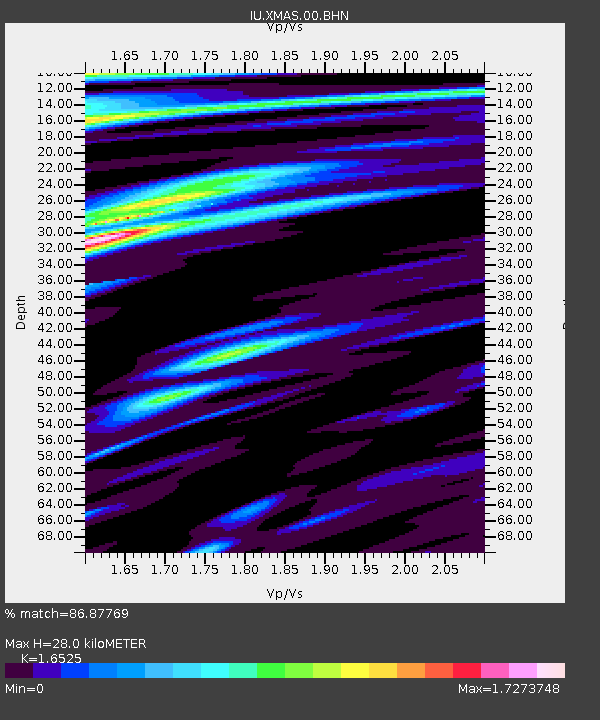
| Estimated Moho Depth: |
28.0 km |
| Estimated Crust Vp/Vs: |
1.65 |
| Assumed Crust Vp: |
4.802 km/s |
| Estimated Crust Vs: |
2.906 km/s |
| Estimated Crust Poisson's Ratio: |
0.21 |
|
| Radial Match: |
86.87769 % |
| Radial Bump: |
341 |
| Transverse Match: |
84.96415 % |
| Transverse Bump: |
400 |
| SOD ConfigId: |
2564 |
| Insert Time: |
2010-03-02 15:46:37.991 +0000 |
| GWidth: |
2.5 |
| Max Bumps: |
400 |
| Tol: |
0.001 |
|
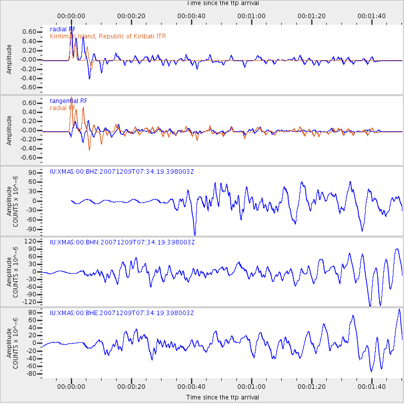
Signal To Noise
| Channel | StoN | STA | LTA |
| IU:XMAS:00:BHN:20071209T07:34:19.398003Z | 1.2408992 | 3.8208054E-6 | 3.079062E-6 |
| IU:XMAS:00:BHE:20071209T07:34:19.398003Z | 0.58120507 | 2.1008395E-6 | 3.614627E-6 |
| IU:XMAS:00:BHZ:20071209T07:34:19.398003Z | 1.9020042 | 7.778439E-6 | 4.089601E-6 |
| Arrivals |
| Ps | 4.0 SECOND |
| PpPs | 15 SECOND |
| PsPs/PpSs | 19 SECOND |


