You are here: Home > Network List > IU - Global Seismograph Network (GSN - IRIS/USGS) Stations List
> Station XMAS Kiritimati Island, Republic of Kiribati > Earthquake Result Viewer
XMAS Kiritimati Island, Republic of Kiribati - Earthquake Result Viewer
| Earthquake location: |
Near West Coast Of Colombia |
| Earthquake latitude/longitude: |
3.0/-78.0 |
| Earthquake time(UTC): |
2007/09/10 (253) 01:49:14 GMT |
| Earthquake Depth: |
31 km |
| Earthquake Magnitude: |
6.1 MB, 6.7 MS, 6.8 MW |
| Earthquake Catalog/Contributor: |
WHDF/NEIC |
|
| Network: |
IU Global Seismograph Network (GSN - IRIS/USGS) |
| Station: |
XMAS Kiritimati Island, Republic of Kiribati |
| Lat/Lon: |
2.04 N/157.45 W |
| Elevation: |
2.0 m |
|
| Distance: |
79.4 deg |
| Az: |
271.514 deg |
| Baz: |
87.366 deg |
| Ray Param: |
0.048950743 |
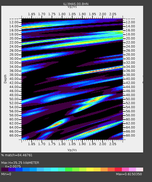
| Estimated Moho Depth: |
35.25 km |
| Estimated Crust Vp/Vs: |
2.01 |
| Assumed Crust Vp: |
4.802 km/s |
| Estimated Crust Vs: |
2.392 km/s |
| Estimated Crust Poisson's Ratio: |
0.33 |
|
| Radial Match: |
84.46761 % |
| Radial Bump: |
400 |
| Transverse Match: |
71.11191 % |
| Transverse Bump: |
400 |
| SOD ConfigId: |
2564 |
| Insert Time: |
2010-03-02 15:46:41.048 +0000 |
| GWidth: |
2.5 |
| Max Bumps: |
400 |
| Tol: |
0.001 |
|
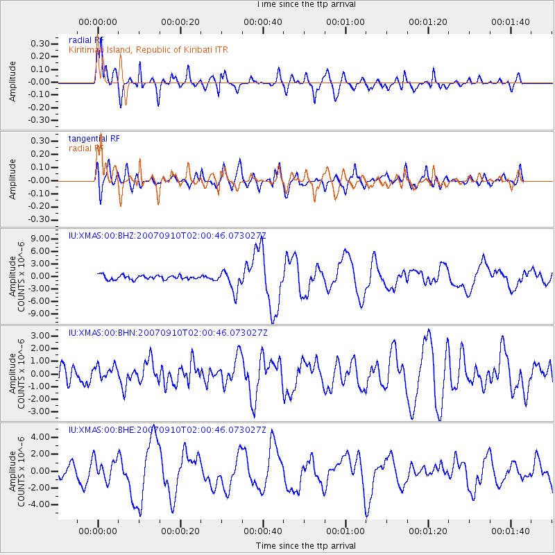
Signal To Noise
| Channel | StoN | STA | LTA |
| IU:XMAS:00:BHN:20070910T02:00:46.073027Z | 0.61580807 | 5.5788564E-7 | 9.0594085E-7 |
| IU:XMAS:00:BHE:20070910T02:00:46.073027Z | 1.2537578 | 1.2357667E-6 | 9.856503E-7 |
| IU:XMAS:00:BHZ:20070910T02:00:46.073027Z | 5.139833 | 2.5113598E-6 | 4.886072E-7 |
| Arrivals |
| Ps | 7.5 SECOND |
| PpPs | 22 SECOND |
| PsPs/PpSs | 29 SECOND |


