You are here: Home > Network List > IU - Global Seismograph Network (GSN - IRIS/USGS) Stations List
> Station XMAS Kiritimati Island, Republic of Kiribati > Earthquake Result Viewer
XMAS Kiritimati Island, Republic of Kiribati - Earthquake Result Viewer
| Earthquake location: |
Loyalty Islands |
| Earthquake latitude/longitude: |
-20.1/168.9 |
| Earthquake time(UTC): |
2008/04/09 (100) 12:46:12 GMT |
| Earthquake Depth: |
33 km |
| Earthquake Magnitude: |
6.3 MB, 7.3 MS, 7.3 MW, 7.3 MW |
| Earthquake Catalog/Contributor: |
WHDF/NEIC |
|
| Network: |
IU Global Seismograph Network (GSN - IRIS/USGS) |
| Station: |
XMAS Kiritimati Island, Republic of Kiribati |
| Lat/Lon: |
2.04 N/157.45 W |
| Elevation: |
2.0 m |
|
| Distance: |
39.7 deg |
| Az: |
60.213 deg |
| Baz: |
234.718 deg |
| Ray Param: |
0.07478954 |
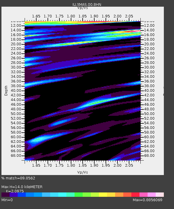
| Estimated Moho Depth: |
14.0 km |
| Estimated Crust Vp/Vs: |
2.10 |
| Assumed Crust Vp: |
4.802 km/s |
| Estimated Crust Vs: |
2.289 km/s |
| Estimated Crust Poisson's Ratio: |
0.35 |
|
| Radial Match: |
89.8562 % |
| Radial Bump: |
331 |
| Transverse Match: |
66.387 % |
| Transverse Bump: |
326 |
| SOD ConfigId: |
2504 |
| Insert Time: |
2010-03-02 15:46:47.352 +0000 |
| GWidth: |
2.5 |
| Max Bumps: |
400 |
| Tol: |
0.001 |
|

Signal To Noise
| Channel | StoN | STA | LTA |
| IU:XMAS:00:BHN:20080409T12:53:11.08499Z | 4.815533 | 9.896202E-6 | 2.0550583E-6 |
| IU:XMAS:00:BHE:20080409T12:53:11.08499Z | 1.1843112 | 3.8294143E-6 | 3.2334526E-6 |
| IU:XMAS:00:BHZ:20080409T12:53:11.08499Z | 0.9206803 | 3.4795526E-6 | 3.779328E-6 |
| Arrivals |
| Ps | 3.3 SECOND |
| PpPs | 8.7 SECOND |
| PsPs/PpSs | 12 SECOND |


