You are here: Home > Network List > IU - Global Seismograph Network (GSN - IRIS/USGS) Stations List
> Station XMAS Kiritimati Island, Republic of Kiribati > Earthquake Result Viewer
XMAS Kiritimati Island, Republic of Kiribati - Earthquake Result Viewer

| Earthquake location: |
Eastern Honshu, Japan |
| Earthquake latitude/longitude: |
39.8/141.5 |
| Earthquake time(UTC): |
2008/07/23 (205) 15:26:19 GMT |
| Earthquake Depth: |
108 km |
| Earthquake Magnitude: |
6.6 MB, 6.8 MW, 6.8 MW |
| Earthquake Catalog/Contributor: |
WHDF/NEIC |
|
| Network: |
IU Global Seismograph Network (GSN - IRIS/USGS) |
| Station: |
XMAS Kiritimati Island, Republic of Kiribati |
| Lat/Lon: |
2.04 N/157.45 W |
| Elevation: |
2.0 m |
|
| Distance: |
66.7 deg |
| Az: |
107.791 deg |
| Baz: |
312.778 deg |
| Ray Param: |
0.057123035 |
| Estimated Moho Depth: |
19.75 km |
| Estimated Crust Vp/Vs: |
1.73 |
| Assumed Crust Vp: |
4.802 km/s |
| Estimated Crust Vs: |
2.776 km/s |
| Estimated Crust Poisson's Ratio: |
0.25 |
|
| Radial Match: |
93.76755 % |
| Radial Bump: |
400 |
| Transverse Match: |
84.2294 % |
| Transverse Bump: |
400 |
| SOD ConfigId: |
2504 |
| Insert Time: |
2010-03-02 15:46:54.844 +0000 |
| GWidth: |
2.5 |
| Max Bumps: |
400 |
| Tol: |
0.001 |
|
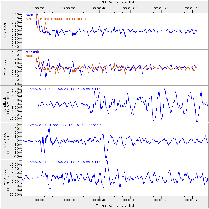
Signal To Noise
| Channel | StoN | STA | LTA |
| IU:XMAS:00:BHN:20080723T15:36:28.861011Z | 7.064685 | 1.0668102E-5 | 1.5100605E-6 |
| IU:XMAS:00:BHE:20080723T15:36:28.861011Z | 1.980617 | 2.6581017E-6 | 1.3420574E-6 |
| IU:XMAS:00:BHZ:20080723T15:36:28.861011Z | 1.8706663 | 2.3757586E-6 | 1.2700067E-6 |
| Arrivals |
| Ps | 3.1 SECOND |
| PpPs | 11 SECOND |
| PsPs/PpSs | 14 SECOND |


