You are here: Home > Network List > IU - Global Seismograph Network (GSN - IRIS/USGS) Stations List
> Station XMAS Kiritimati Island, Republic of Kiribati > Earthquake Result Viewer
XMAS Kiritimati Island, Republic of Kiribati - Earthquake Result Viewer

| Earthquake location: |
North Of Honduras |
| Earthquake latitude/longitude: |
16.7/-86.2 |
| Earthquake time(UTC): |
2009/05/28 (148) 08:24:45 GMT |
| Earthquake Depth: |
10 km |
| Earthquake Magnitude: |
6.7 MB, 7.2 MS, 7.3 MW, 7.3 MW |
| Earthquake Catalog/Contributor: |
WHDF/NEIC |
|
| Network: |
IU Global Seismograph Network (GSN - IRIS/USGS) |
| Station: |
XMAS Kiritimati Island, Republic of Kiribati |
| Lat/Lon: |
2.04 N/157.45 W |
| Elevation: |
20 m |
|
| Distance: |
71.4 deg |
| Az: |
266.488 deg |
| Baz: |
73.147 deg |
| Ray Param: |
0.054337192 |
| Estimated Moho Depth: |
23.75 km |
| Estimated Crust Vp/Vs: |
1.84 |
| Assumed Crust Vp: |
4.802 km/s |
| Estimated Crust Vs: |
2.606 km/s |
| Estimated Crust Poisson's Ratio: |
0.29 |
|
| Radial Match: |
95.951675 % |
| Radial Bump: |
362 |
| Transverse Match: |
92.09234 % |
| Transverse Bump: |
400 |
| SOD ConfigId: |
2648 |
| Insert Time: |
2010-03-02 15:47:04.525 +0000 |
| GWidth: |
2.5 |
| Max Bumps: |
400 |
| Tol: |
0.001 |
|
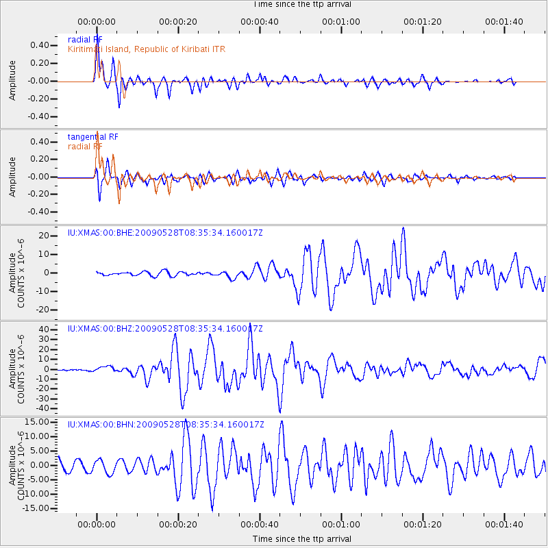
Signal To Noise
| Channel | StoN | STA | LTA |
| IU:XMAS:00:BHZ:20090528T08:35:34.160017Z | 2.650301 | 2.8603208E-6 | 1.0792438E-6 |
| IU:XMAS:00:BHN:20090528T08:35:34.160017Z | 1.4627672 | 2.245019E-6 | 1.5347754E-6 |
| IU:XMAS:00:BHE:20090528T08:35:34.160017Z | 1.8084267 | 1.955034E-6 | 1.081069E-6 |
| Arrivals |
| Ps | 4.2 SECOND |
| PpPs | 14 SECOND |
| PsPs/PpSs | 18 SECOND |


