You are here: Home > Network List > CH - Switzerland Seismological Network Stations List
> Station BRANT Les Verrieres > Earthquake Result Viewer
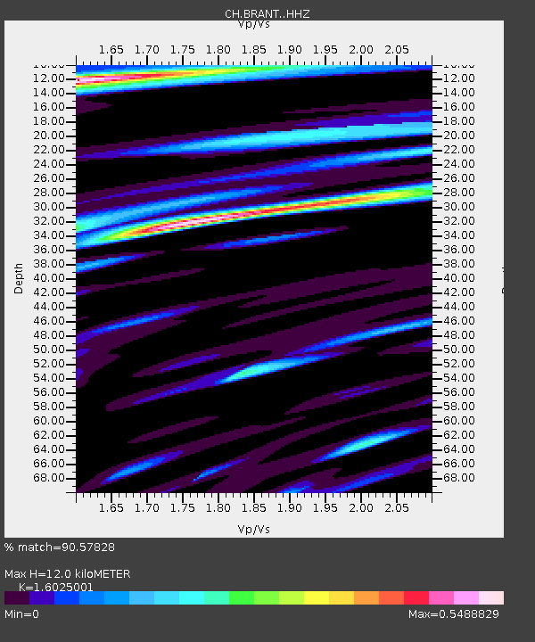
BRANT Les Verrieres - Earthquake Result Viewer
| Earthquake location: |
Alaska Peninsula |
| Earthquake latitude/longitude: |
56.7/-156.5 |
| Earthquake time(UTC): |
2015/05/29 (149) 07:00:08 GMT |
| Earthquake Depth: |
62 km |
| Earthquake Magnitude: |
6.8 MWP, 6.8 MI |
| Earthquake Catalog/Contributor: |
NEIC PDE/NEIC COMCAT |
|
| Network: |
CH Switzerland Seismological Network |
| Station: |
BRANT Les Verrieres |
| Lat/Lon: |
46.94 N/6.47 E |
| Elevation: |
1145 m |
|
| Distance: |
75.8 deg |
| Az: |
11.926 deg |
| Baz: |
350.423 deg |
| Ray Param: |
0.051323187 |
| Estimated Moho Depth: |
12.0 km |
| Estimated Crust Vp/Vs: |
1.60 |
| Assumed Crust Vp: |
6.276 km/s |
| Estimated Crust Vs: |
3.916 km/s |
| Estimated Crust Poisson's Ratio: |
0.18 |
|
| Radial Match: |
90.57828 % |
| Radial Bump: |
400 |
| Transverse Match: |
82.1275 % |
| Transverse Bump: |
400 |
| SOD ConfigId: |
7422571 |
| Insert Time: |
2019-04-19 02:34:33.691 +0000 |
| GWidth: |
2.5 |
| Max Bumps: |
400 |
| Tol: |
0.001 |
|

Signal To Noise
| Channel | StoN | STA | LTA |
| CH:BRANT: :HHZ:20150529T07:11:15.898972Z | 46.577644 | 5.3865965E-6 | 1.1564769E-7 |
| CH:BRANT: :HHN:20150529T07:11:15.898972Z | 17.347324 | 1.8880439E-6 | 1.0883777E-7 |
| CH:BRANT: :HHE:20150529T07:11:15.898972Z | 2.818557 | 2.8794122E-7 | 1.02159085E-7 |
| Arrivals |
| Ps | 1.2 SECOND |
| PpPs | 4.8 SECOND |
| PsPs/PpSs | 6.0 SECOND |


