You are here: Home > Network List > TA - USArray Transportable Network (new EarthScope stations) Stations List
> Station Y56A Pelion, SC, USA > Earthquake Result Viewer
Y56A Pelion, SC, USA - Earthquake Result Viewer
*The percent match for this event was below the threshold and hence no stack was calculated.
| Earthquake location: |
Rat Islands, Aleutian Islands |
| Earthquake latitude/longitude: |
51.9/179.6 |
| Earthquake time(UTC): |
2015/01/18 (018) 04:47:38 GMT |
| Earthquake Depth: |
106 km |
| Earthquake Magnitude: |
5.8 MB, 5.9 MB |
| Earthquake Catalog/Contributor: |
NEIC PDE/NEIC COMCAT |
|
| Network: |
TA USArray Transportable Network (new EarthScope stations) |
| Station: |
Y56A Pelion, SC, USA |
| Lat/Lon: |
33.79 N/81.30 W |
| Elevation: |
154 m |
|
| Distance: |
69.3 deg |
| Az: |
61.487 deg |
| Baz: |
319.178 deg |
| Ray Param: |
$rayparam |
*The percent match for this event was below the threshold and hence was not used in the summary stack. |
|
| Radial Match: |
44.054092 % |
| Radial Bump: |
400 |
| Transverse Match: |
68.51617 % |
| Transverse Bump: |
400 |
| SOD ConfigId: |
837871 |
| Insert Time: |
2015-02-01 05:23:23.046 +0000 |
| GWidth: |
2.5 |
| Max Bumps: |
400 |
| Tol: |
0.001 |
|
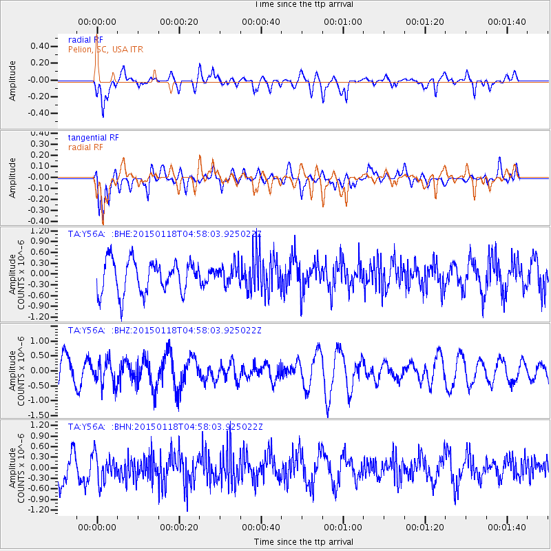
Signal To Noise
| Channel | StoN | STA | LTA |
| TA:Y56A: :BHZ:20150118T04:58:03.925022Z | 1.0678136 | 4.2597324E-7 | 3.9892097E-7 |
| TA:Y56A: :BHN:20150118T04:58:03.925022Z | 1.0251749 | 4.1675332E-7 | 4.0651926E-7 |
| TA:Y56A: :BHE:20150118T04:58:03.925022Z | 0.6100386 | 2.759988E-7 | 4.524284E-7 |
| Arrivals |
| Ps | |
| PpPs | |
| PsPs/PpSs | |


