You are here: Home > Network List > IU - Global Seismograph Network (GSN - IRIS/USGS) Stations List
> Station XMAS Kiritimati Island, Republic of Kiribati > Earthquake Result Viewer
XMAS Kiritimati Island, Republic of Kiribati - Earthquake Result Viewer
| Earthquake location: |
East Of Kuril Islands |
| Earthquake latitude/longitude: |
46.9/155.2 |
| Earthquake time(UTC): |
2009/01/15 (015) 17:49:39 GMT |
| Earthquake Depth: |
36 km |
| Earthquake Magnitude: |
6.9 MB, 7.5 MS, 7.4 MW, 7.4 MW |
| Earthquake Catalog/Contributor: |
WHDF/NEIC |
|
| Network: |
IU Global Seismograph Network (GSN - IRIS/USGS) |
| Station: |
XMAS Kiritimati Island, Republic of Kiribati |
| Lat/Lon: |
2.04 N/157.45 W |
| Elevation: |
2.0 m |
|
| Distance: |
60.7 deg |
| Az: |
122.446 deg |
| Baz: |
324.585 deg |
| Ray Param: |
0.06132064 |
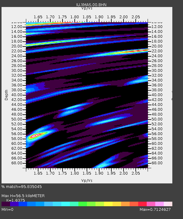
| Estimated Moho Depth: |
56.5 km |
| Estimated Crust Vp/Vs: |
1.64 |
| Assumed Crust Vp: |
4.802 km/s |
| Estimated Crust Vs: |
2.932 km/s |
| Estimated Crust Poisson's Ratio: |
0.20 |
|
| Radial Match: |
95.835045 % |
| Radial Bump: |
323 |
| Transverse Match: |
93.03953 % |
| Transverse Bump: |
352 |
| SOD ConfigId: |
2658 |
| Insert Time: |
2010-03-02 15:47:10.053 +0000 |
| GWidth: |
2.5 |
| Max Bumps: |
400 |
| Tol: |
0.001 |
|

Signal To Noise
| Channel | StoN | STA | LTA |
| IU:XMAS:00:BHN:20090115T17:59:15.811028Z | 11.548966 | 1.2136766E-5 | 1.0508963E-6 |
| IU:XMAS:00:BHE:20090115T17:59:15.811028Z | 6.133192 | 6.6570965E-6 | 1.0854212E-6 |
| IU:XMAS:00:BHZ:20090115T17:59:15.811028Z | 3.225998 | 3.1251284E-6 | 9.687324E-7 |
| Arrivals |
| Ps | 7.7 SECOND |
| PpPs | 30 SECOND |
| PsPs/PpSs | 38 SECOND |


