You are here: Home > Network List > IU - Global Seismograph Network (GSN - IRIS/USGS) Stations List
> Station XMAS Kiritimati Island, Republic of Kiribati > Earthquake Result Viewer
XMAS Kiritimati Island, Republic of Kiribati - Earthquake Result Viewer
| Earthquake location: |
Vanuatu Islands |
| Earthquake latitude/longitude: |
-15.8/167.8 |
| Earthquake time(UTC): |
2006/08/07 (219) 22:18:54 GMT |
| Earthquake Depth: |
141 km |
| Earthquake Magnitude: |
6.0 MB, 6.8 MW, 6.8 MW |
| Earthquake Catalog/Contributor: |
WHDF/NEIC |
|
| Network: |
IU Global Seismograph Network (GSN - IRIS/USGS) |
| Station: |
XMAS Kiritimati Island, Republic of Kiribati |
| Lat/Lon: |
2.04 N/157.45 W |
| Elevation: |
2.0 m |
|
| Distance: |
38.7 deg |
| Az: |
65.805 deg |
| Baz: |
241.495 deg |
| Ray Param: |
0.07493892 |
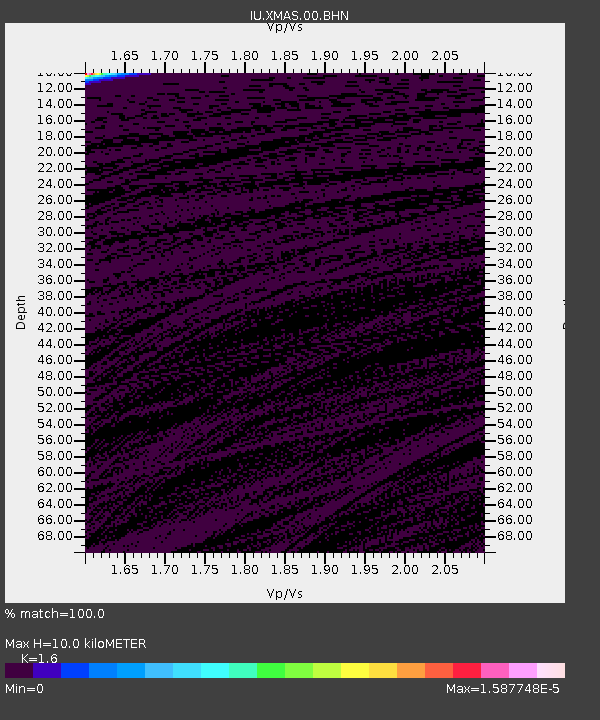
| Estimated Moho Depth: |
10.0 km |
| Estimated Crust Vp/Vs: |
1.60 |
| Assumed Crust Vp: |
4.802 km/s |
| Estimated Crust Vs: |
3.001 km/s |
| Estimated Crust Poisson's Ratio: |
0.18 |
|
| Radial Match: |
100.0 % |
| Radial Bump: |
2 |
| Transverse Match: |
100.0 % |
| Transverse Bump: |
2 |
| SOD ConfigId: |
5423 |
| Insert Time: |
2010-03-02 15:47:11.959 +0000 |
| GWidth: |
2.5 |
| Max Bumps: |
400 |
| Tol: |
0.001 |
|

Signal To Noise
| Channel | StoN | STA | LTA |
| IU:XMAS:00:BHN:20060807T22:25:33.46101Z | 0.9138368 | 1.3981462E-7 | 1.5299737E-7 |
| IU:XMAS:00:BHE:20060807T22:25:33.46101Z | 0.9141922 | 1.3979626E-7 | 1.5291779E-7 |
| IU:XMAS:00:BHZ:20060807T22:25:33.46101Z | 0.91390127 | 1.3926072E-7 | 1.523805E-7 |
| Arrivals |
| Ps | 1.3 SECOND |
| PpPs | 5.2 SECOND |
| PsPs/PpSs | 6.5 SECOND |


