You are here: Home > Network List > CI - Caltech Regional Seismic Network Stations List
> Station FMP Fort MacArthur Park, Pt. Fermin San Pedro, CA, USA > Earthquake Result Viewer
FMP Fort MacArthur Park, Pt. Fermin San Pedro, CA, USA - Earthquake Result Viewer

| Earthquake location: |
Alaska Peninsula |
| Earthquake latitude/longitude: |
56.7/-156.5 |
| Earthquake time(UTC): |
2015/05/29 (149) 07:00:08 GMT |
| Earthquake Depth: |
62 km |
| Earthquake Magnitude: |
6.8 MWP, 6.8 MI |
| Earthquake Catalog/Contributor: |
NEIC PDE/NEIC COMCAT |
|
| Network: |
CI Caltech Regional Seismic Network |
| Station: |
FMP Fort MacArthur Park, Pt. Fermin San Pedro, CA, USA |
| Lat/Lon: |
33.71 N/118.29 W |
| Elevation: |
89 m |
|
| Distance: |
34.7 deg |
| Az: |
115.067 deg |
| Baz: |
323.165 deg |
| Ray Param: |
0.07743197 |
| Estimated Moho Depth: |
15.75 km |
| Estimated Crust Vp/Vs: |
2.01 |
| Assumed Crust Vp: |
6.048 km/s |
| Estimated Crust Vs: |
3.005 km/s |
| Estimated Crust Poisson's Ratio: |
0.34 |
|
| Radial Match: |
85.75717 % |
| Radial Bump: |
400 |
| Transverse Match: |
76.153 % |
| Transverse Bump: |
400 |
| SOD ConfigId: |
7422571 |
| Insert Time: |
2019-04-19 02:34:54.116 +0000 |
| GWidth: |
2.5 |
| Max Bumps: |
400 |
| Tol: |
0.001 |
|
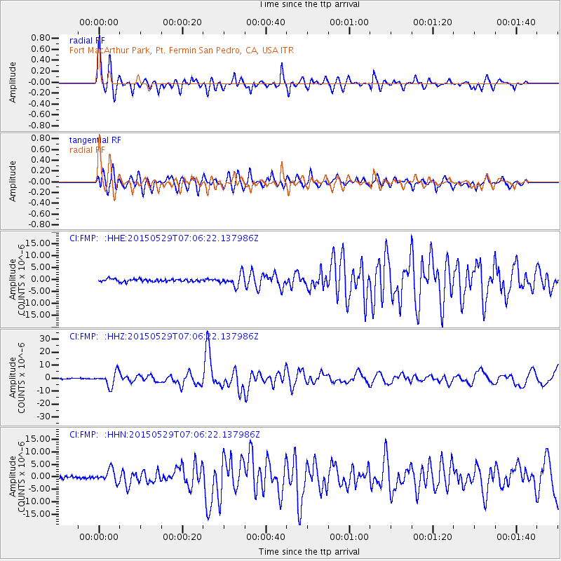
Signal To Noise
| Channel | StoN | STA | LTA |
| CI:FMP: :HHZ:20150529T07:06:22.137986Z | 12.074918 | 5.5073474E-6 | 4.5609815E-7 |
| CI:FMP: :HHN:20150529T07:06:22.137986Z | 5.002704 | 2.556139E-6 | 5.1095145E-7 |
| CI:FMP: :HHE:20150529T07:06:22.137986Z | 4.5879364 | 2.4965188E-6 | 5.441486E-7 |
| Arrivals |
| Ps | 2.8 SECOND |
| PpPs | 7.4 SECOND |
| PsPs/PpSs | 10 SECOND |


