You are here: Home > Network List > CI - Caltech Regional Seismic Network Stations List
> Station LRL Laurel Mtn Radio Fac, Ridgecrest, CA, USA > Earthquake Result Viewer
LRL Laurel Mtn Radio Fac, Ridgecrest, CA, USA - Earthquake Result Viewer
| Earthquake location: |
Alaska Peninsula |
| Earthquake latitude/longitude: |
56.7/-156.5 |
| Earthquake time(UTC): |
2015/05/29 (149) 07:00:08 GMT |
| Earthquake Depth: |
62 km |
| Earthquake Magnitude: |
6.8 MWP, 6.8 MI |
| Earthquake Catalog/Contributor: |
NEIC PDE/NEIC COMCAT |
|
| Network: |
CI Caltech Regional Seismic Network |
| Station: |
LRL Laurel Mtn Radio Fac, Ridgecrest, CA, USA |
| Lat/Lon: |
35.48 N/117.68 W |
| Elevation: |
1340 m |
|
| Distance: |
33.6 deg |
| Az: |
112.435 deg |
| Baz: |
321.333 deg |
| Ray Param: |
0.077969305 |
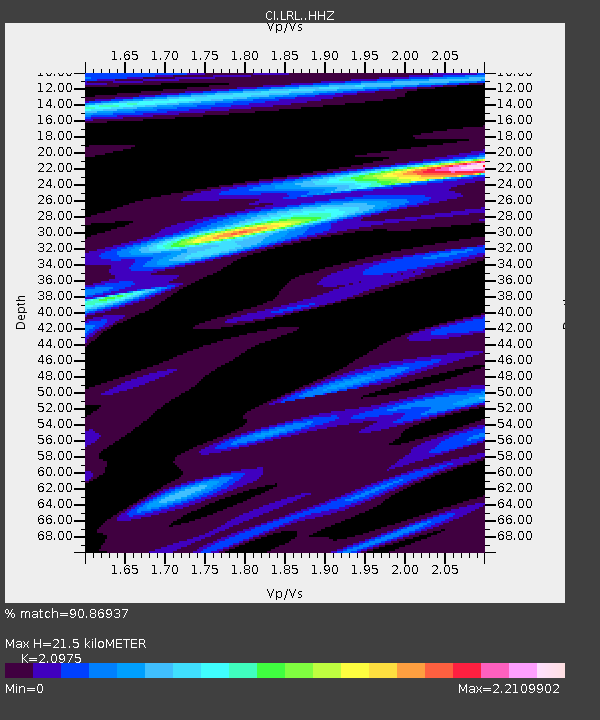
| Estimated Moho Depth: |
21.5 km |
| Estimated Crust Vp/Vs: |
2.10 |
| Assumed Crust Vp: |
6.276 km/s |
| Estimated Crust Vs: |
2.992 km/s |
| Estimated Crust Poisson's Ratio: |
0.35 |
|
| Radial Match: |
90.86937 % |
| Radial Bump: |
317 |
| Transverse Match: |
75.33651 % |
| Transverse Bump: |
400 |
| SOD ConfigId: |
7422571 |
| Insert Time: |
2019-04-19 02:35:02.183 +0000 |
| GWidth: |
2.5 |
| Max Bumps: |
400 |
| Tol: |
0.001 |
|

Signal To Noise
| Channel | StoN | STA | LTA |
| CI:LRL: :HHZ:20150529T07:06:12.78801Z | 49.231007 | 5.7080038E-6 | 1.1594327E-7 |
| CI:LRL: :HHN:20150529T07:06:12.78801Z | 26.781445 | 3.102226E-6 | 1.158349E-7 |
| CI:LRL: :HHE:20150529T07:06:12.78801Z | 13.607917 | 2.43846E-6 | 1.7919422E-7 |
| Arrivals |
| Ps | 4.0 SECOND |
| PpPs | 10.0 SECOND |
| PsPs/PpSs | 14 SECOND |


