You are here: Home > Network List > CI - Caltech Regional Seismic Network Stations List
> Station SCZ2 SCZ2, Santa Cruz Is. (E end), CA, USA > Earthquake Result Viewer
SCZ2 SCZ2, Santa Cruz Is. (E end), CA, USA - Earthquake Result Viewer

| Earthquake location: |
Alaska Peninsula |
| Earthquake latitude/longitude: |
56.7/-156.5 |
| Earthquake time(UTC): |
2015/05/29 (149) 07:00:08 GMT |
| Earthquake Depth: |
62 km |
| Earthquake Magnitude: |
6.8 MWP, 6.8 MI |
| Earthquake Catalog/Contributor: |
NEIC PDE/NEIC COMCAT |
|
| Network: |
CI Caltech Regional Seismic Network |
| Station: |
SCZ2 SCZ2, Santa Cruz Is. (E end), CA, USA |
| Lat/Lon: |
34.00 N/119.64 W |
| Elevation: |
440 m |
|
| Distance: |
33.8 deg |
| Az: |
116.357 deg |
| Baz: |
323.487 deg |
| Ray Param: |
0.07788113 |
| Estimated Moho Depth: |
20.75 km |
| Estimated Crust Vp/Vs: |
1.96 |
| Assumed Crust Vp: |
6.048 km/s |
| Estimated Crust Vs: |
3.086 km/s |
| Estimated Crust Poisson's Ratio: |
0.32 |
|
| Radial Match: |
90.137024 % |
| Radial Bump: |
400 |
| Transverse Match: |
86.418945 % |
| Transverse Bump: |
400 |
| SOD ConfigId: |
7422571 |
| Insert Time: |
2019-04-19 02:35:15.374 +0000 |
| GWidth: |
2.5 |
| Max Bumps: |
400 |
| Tol: |
0.001 |
|
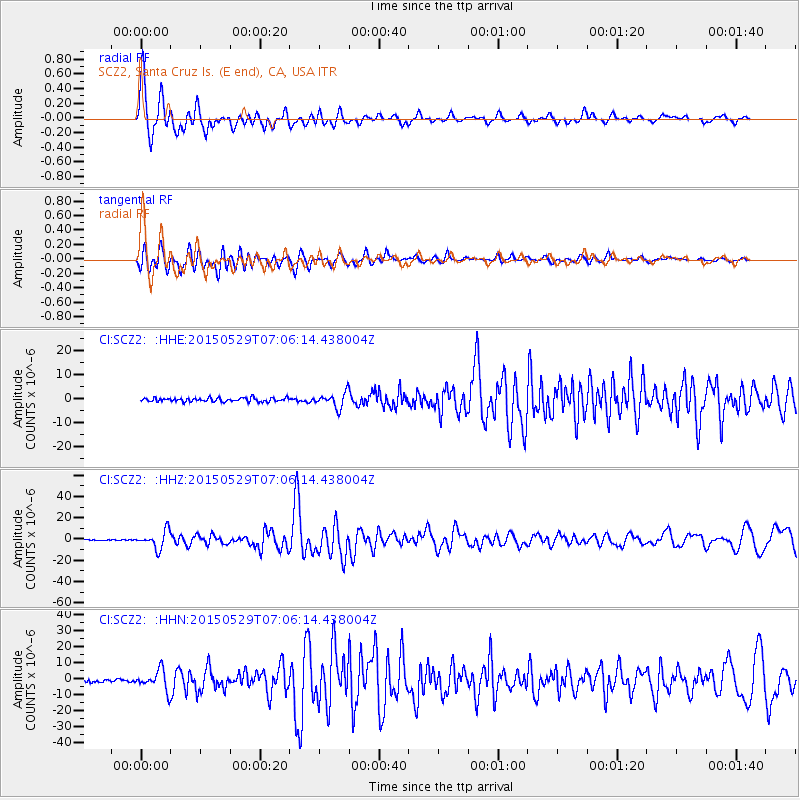
Signal To Noise
| Channel | StoN | STA | LTA |
| CI:SCZ2: :HHZ:20150529T07:06:14.438004Z | 20.349924 | 8.2993765E-6 | 4.0783328E-7 |
| CI:SCZ2: :HHN:20150529T07:06:14.438004Z | 6.7987013 | 6.2022646E-6 | 9.1227196E-7 |
| CI:SCZ2: :HHE:20150529T07:06:14.438004Z | 3.9658167 | 3.0843662E-6 | 7.777379E-7 |
| Arrivals |
| Ps | 3.5 SECOND |
| PpPs | 9.6 SECOND |
| PsPs/PpSs | 13 SECOND |


