You are here: Home > Network List > CI - Caltech Regional Seismic Network Stations List
> Station SMM Simmler, CA, USA > Earthquake Result Viewer
SMM Simmler, CA, USA - Earthquake Result Viewer
| Earthquake location: |
Alaska Peninsula |
| Earthquake latitude/longitude: |
56.7/-156.5 |
| Earthquake time(UTC): |
2015/05/29 (149) 07:00:08 GMT |
| Earthquake Depth: |
62 km |
| Earthquake Magnitude: |
6.8 MWP, 6.8 MI |
| Earthquake Catalog/Contributor: |
NEIC PDE/NEIC COMCAT |
|
| Network: |
CI Caltech Regional Seismic Network |
| Station: |
SMM Simmler, CA, USA |
| Lat/Lon: |
35.31 N/120.00 W |
| Elevation: |
599 m |
|
| Distance: |
32.6 deg |
| Az: |
115.344 deg |
| Baz: |
322.435 deg |
| Ray Param: |
0.078445755 |
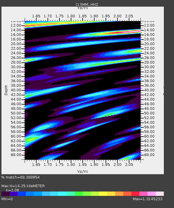
| Estimated Moho Depth: |
14.25 km |
| Estimated Crust Vp/Vs: |
2.09 |
| Assumed Crust Vp: |
6.1 km/s |
| Estimated Crust Vs: |
2.919 km/s |
| Estimated Crust Poisson's Ratio: |
0.35 |
|
| Radial Match: |
88.388954 % |
| Radial Bump: |
400 |
| Transverse Match: |
89.20477 % |
| Transverse Bump: |
400 |
| SOD ConfigId: |
7422571 |
| Insert Time: |
2019-04-19 02:35:18.431 +0000 |
| GWidth: |
2.5 |
| Max Bumps: |
400 |
| Tol: |
0.001 |
|
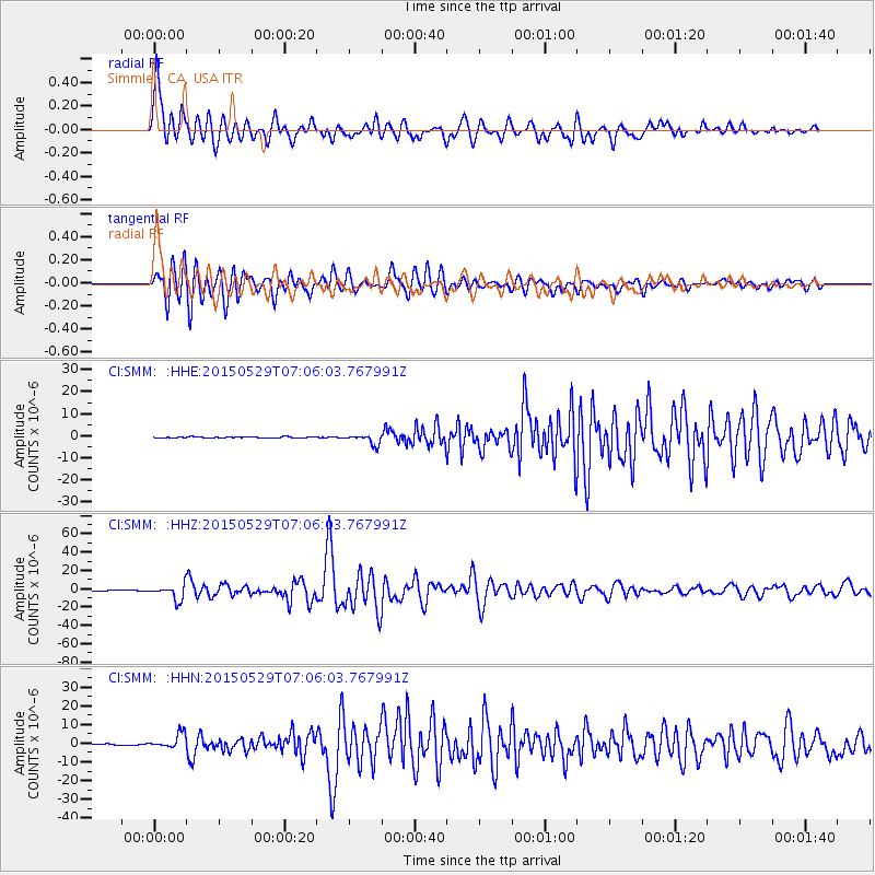
Signal To Noise
| Channel | StoN | STA | LTA |
| CI:SMM: :HHZ:20150529T07:06:03.767991Z | 34.48897 | 8.318575E-6 | 2.411952E-7 |
| CI:SMM: :HHN:20150529T07:06:03.767991Z | 13.213899 | 4.055316E-6 | 3.0689776E-7 |
| CI:SMM: :HHE:20150529T07:06:03.767991Z | 9.080142 | 2.3268244E-6 | 2.562542E-7 |
| Arrivals |
| Ps | 2.7 SECOND |
| PpPs | 6.8 SECOND |
| PsPs/PpSs | 9.5 SECOND |


