You are here: Home > Network List > CN - Canadian National Seismograph Network Stations List
> Station KAPO KAPUSKASING, ON > Earthquake Result Viewer
KAPO KAPUSKASING, ON - Earthquake Result Viewer
| Earthquake location: |
Alaska Peninsula |
| Earthquake latitude/longitude: |
56.7/-156.5 |
| Earthquake time(UTC): |
2015/05/29 (149) 07:00:08 GMT |
| Earthquake Depth: |
62 km |
| Earthquake Magnitude: |
6.8 MWP, 6.8 MI |
| Earthquake Catalog/Contributor: |
NEIC PDE/NEIC COMCAT |
|
| Network: |
CN Canadian National Seismograph Network |
| Station: |
KAPO KAPUSKASING, ON |
| Lat/Lon: |
49.45 N/82.51 W |
| Elevation: |
210 m |
|
| Distance: |
43.0 deg |
| Az: |
66.857 deg |
| Baz: |
308.985 deg |
| Ray Param: |
0.0726307 |
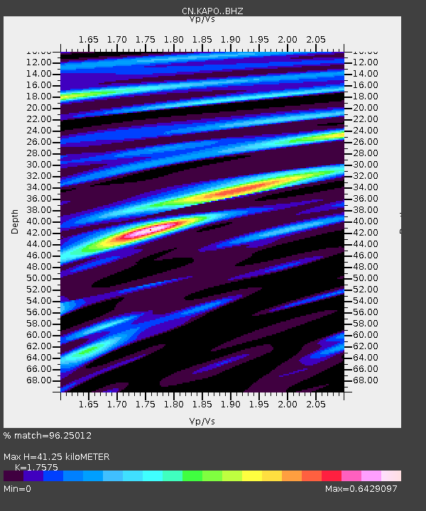
| Estimated Moho Depth: |
41.25 km |
| Estimated Crust Vp/Vs: |
1.76 |
| Assumed Crust Vp: |
6.467 km/s |
| Estimated Crust Vs: |
3.679 km/s |
| Estimated Crust Poisson's Ratio: |
0.26 |
|
| Radial Match: |
96.25012 % |
| Radial Bump: |
302 |
| Transverse Match: |
77.475685 % |
| Transverse Bump: |
400 |
| SOD ConfigId: |
7422571 |
| Insert Time: |
2019-04-19 02:35:43.775 +0000 |
| GWidth: |
2.5 |
| Max Bumps: |
400 |
| Tol: |
0.001 |
|

Signal To Noise
| Channel | StoN | STA | LTA |
| CN:KAPO: :BHZ:20150529T07:07:31.300004Z | 64.005775 | 4.257099E-6 | 6.651117E-8 |
| CN:KAPO: :BHN:20150529T07:07:31.300004Z | 19.276651 | 1.455236E-6 | 7.549215E-8 |
| CN:KAPO: :BHE:20150529T07:07:31.300004Z | 33.44315 | 1.866406E-6 | 5.580832E-8 |
| Arrivals |
| Ps | 5.2 SECOND |
| PpPs | 16 SECOND |
| PsPs/PpSs | 22 SECOND |


