You are here: Home > Network List > US - United States National Seismic Network Stations List
> Station EGMT Eagleton, Montana, USA > Earthquake Result Viewer
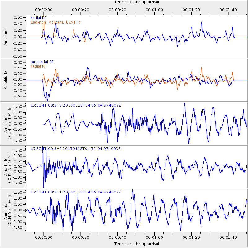
EGMT Eagleton, Montana, USA - Earthquake Result Viewer
*The percent match for this event was below the threshold and hence no stack was calculated.
| Earthquake location: |
Rat Islands, Aleutian Islands |
| Earthquake latitude/longitude: |
51.9/179.6 |
| Earthquake time(UTC): |
2015/01/18 (018) 04:47:38 GMT |
| Earthquake Depth: |
106 km |
| Earthquake Magnitude: |
5.8 MB, 5.9 MB |
| Earthquake Catalog/Contributor: |
NEIC PDE/NEIC COMCAT |
|
| Network: |
US United States National Seismic Network |
| Station: |
EGMT Eagleton, Montana, USA |
| Lat/Lon: |
48.02 N/109.75 W |
| Elevation: |
1055 m |
|
| Distance: |
44.0 deg |
| Az: |
65.79 deg |
| Baz: |
302.678 deg |
| Ray Param: |
$rayparam |
*The percent match for this event was below the threshold and hence was not used in the summary stack. |
|
| Radial Match: |
61.93439 % |
| Radial Bump: |
400 |
| Transverse Match: |
58.622715 % |
| Transverse Bump: |
400 |
| SOD ConfigId: |
837871 |
| Insert Time: |
2015-02-01 05:24:38.467 +0000 |
| GWidth: |
2.5 |
| Max Bumps: |
400 |
| Tol: |
0.001 |
|
Signal To Noise
| Channel | StoN | STA | LTA |
| US:EGMT:00:BHZ:20150118T04:55:04.974003Z | 1.7681361 | 8.424271E-7 | 4.764492E-7 |
| US:EGMT:00:BH1:20150118T04:55:04.974003Z | 1.1094173 | 5.0504093E-7 | 4.5523078E-7 |
| US:EGMT:00:BH2:20150118T04:55:04.974003Z | 1.3161323 | 5.7186423E-7 | 4.345036E-7 |
| Arrivals |
| Ps | |
| PpPs | |
| PsPs/PpSs | |


