You are here: Home > Network List > IU - Global Seismograph Network (GSN - IRIS/USGS) Stations List
> Station XMAS Kiritimati Island, Republic of Kiribati > Earthquake Result Viewer
XMAS Kiritimati Island, Republic of Kiribati - Earthquake Result Viewer
| Earthquake location: |
Mariana Islands Region |
| Earthquake latitude/longitude: |
20.8/146.2 |
| Earthquake time(UTC): |
2006/02/14 (045) 15:27:23 GMT |
| Earthquake Depth: |
40 km |
| Earthquake Magnitude: |
6.2 MB, 6.1 MS, 6.3 MW, 6.2 MW |
| Earthquake Catalog/Contributor: |
WHDF/NEIC |
|
| Network: |
IU Global Seismograph Network (GSN - IRIS/USGS) |
| Station: |
XMAS Kiritimati Island, Republic of Kiribati |
| Lat/Lon: |
2.04 N/157.45 W |
| Elevation: |
2.0 m |
|
| Distance: |
58.0 deg |
| Az: |
101.043 deg |
| Baz: |
293.257 deg |
| Ray Param: |
0.06306323 |
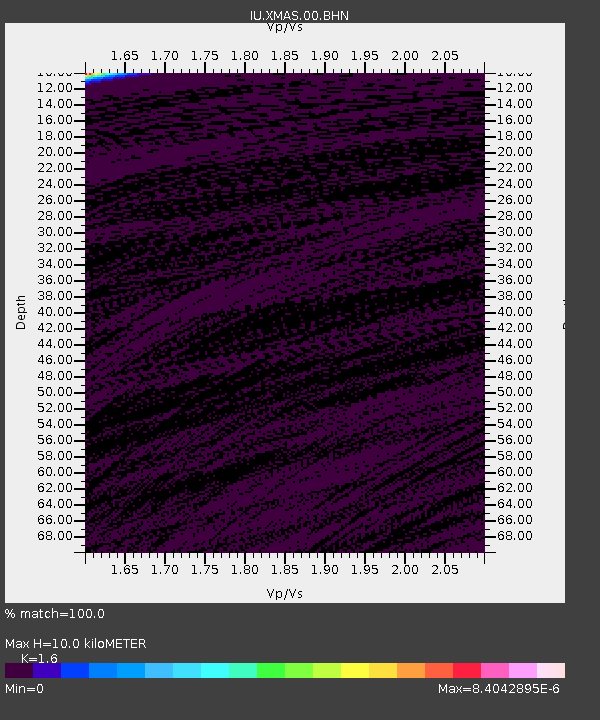
| Estimated Moho Depth: |
10.0 km |
| Estimated Crust Vp/Vs: |
1.60 |
| Assumed Crust Vp: |
4.802 km/s |
| Estimated Crust Vs: |
3.001 km/s |
| Estimated Crust Poisson's Ratio: |
0.18 |
|
| Radial Match: |
100.0 % |
| Radial Bump: |
2 |
| Transverse Match: |
100.00001 % |
| Transverse Bump: |
2 |
| SOD ConfigId: |
5423 |
| Insert Time: |
2010-03-02 15:47:49.223 +0000 |
| GWidth: |
2.5 |
| Max Bumps: |
400 |
| Tol: |
0.001 |
|
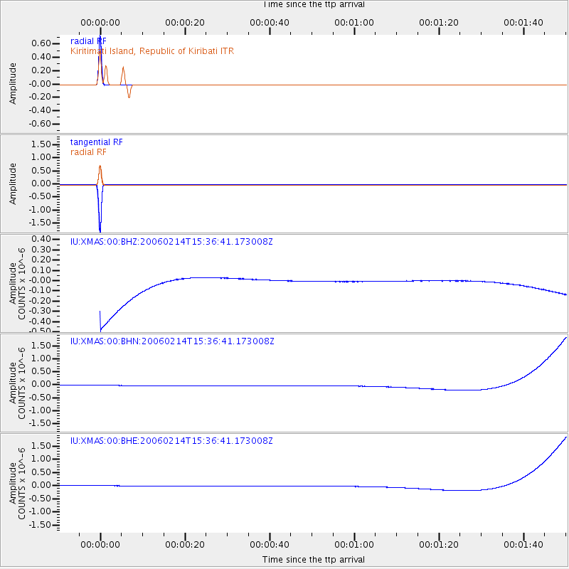
Signal To Noise
| Channel | StoN | STA | LTA |
| IU:XMAS:00:BHN:20060214T15:36:41.173008Z | 0.91207176 | 1.3990633E-7 | 1.5339398E-7 |
| IU:XMAS:00:BHE:20060214T15:36:41.173008Z | 0.91162914 | 1.3976582E-7 | 1.5331433E-7 |
| IU:XMAS:00:BHZ:20060214T15:36:41.173008Z | 0.91209555 | 1.3931252E-7 | 1.5273895E-7 |
| Arrivals |
| Ps | 1.3 SECOND |
| PpPs | 5.3 SECOND |
| PsPs/PpSs | 6.5 SECOND |


