You are here: Home > Network List > JP - Japan Meteorological Agency Seismic Network Stations List
> Station JOW Okinawa Kunigami > Earthquake Result Viewer
JOW Okinawa Kunigami - Earthquake Result Viewer
| Earthquake location: |
Alaska Peninsula |
| Earthquake latitude/longitude: |
56.7/-156.5 |
| Earthquake time(UTC): |
2015/05/29 (149) 07:00:08 GMT |
| Earthquake Depth: |
62 km |
| Earthquake Magnitude: |
6.8 MWP, 6.8 MI |
| Earthquake Catalog/Contributor: |
NEIC PDE/NEIC COMCAT |
|
| Network: |
JP Japan Meteorological Agency Seismic Network |
| Station: |
JOW Okinawa Kunigami |
| Lat/Lon: |
26.84 N/128.27 E |
| Elevation: |
220 m |
|
| Distance: |
60.0 deg |
| Az: |
273.796 deg |
| Baz: |
38.03 deg |
| Ray Param: |
0.061687134 |
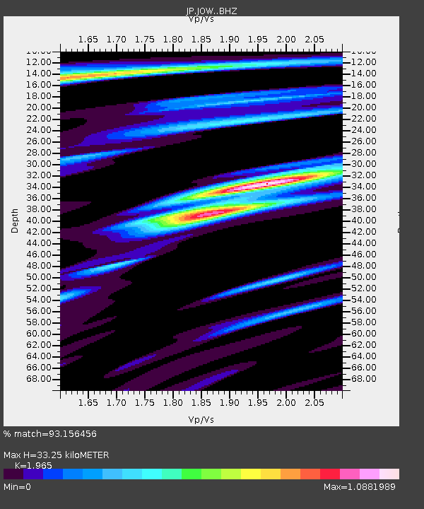
| Estimated Moho Depth: |
33.25 km |
| Estimated Crust Vp/Vs: |
1.97 |
| Assumed Crust Vp: |
6.183 km/s |
| Estimated Crust Vs: |
3.146 km/s |
| Estimated Crust Poisson's Ratio: |
0.33 |
|
| Radial Match: |
93.156456 % |
| Radial Bump: |
400 |
| Transverse Match: |
85.27058 % |
| Transverse Bump: |
400 |
| SOD ConfigId: |
7422571 |
| Insert Time: |
2019-04-19 02:37:33.492 +0000 |
| GWidth: |
2.5 |
| Max Bumps: |
400 |
| Tol: |
0.001 |
|

Signal To Noise
| Channel | StoN | STA | LTA |
| JP:JOW: :BHZ:20150529T07:09:36.449998Z | 22.955856 | 8.926565E-6 | 3.8885787E-7 |
| JP:JOW: :BHN:20150529T07:09:36.449998Z | 12.781568 | 3.6159258E-6 | 2.829016E-7 |
| JP:JOW: :BHE:20150529T07:09:36.449998Z | 4.068121 | 1.991243E-6 | 4.8947487E-7 |
| Arrivals |
| Ps | 5.4 SECOND |
| PpPs | 15 SECOND |
| PsPs/PpSs | 21 SECOND |


