You are here: Home > Network List > KN - Kyrgyz Seismic Telemetry Network Stations List
> Station EKS2 KN.EKS2 > Earthquake Result Viewer
EKS2 KN.EKS2 - Earthquake Result Viewer
| Earthquake location: |
Alaska Peninsula |
| Earthquake latitude/longitude: |
56.7/-156.5 |
| Earthquake time(UTC): |
2015/05/29 (149) 07:00:08 GMT |
| Earthquake Depth: |
62 km |
| Earthquake Magnitude: |
6.8 MWP, 6.8 MI |
| Earthquake Catalog/Contributor: |
NEIC PDE/NEIC COMCAT |
|
| Network: |
KN Kyrgyz Seismic Telemetry Network |
| Station: |
EKS2 KN.EKS2 |
| Lat/Lon: |
42.66 N/73.78 E |
| Elevation: |
1360 m |
|
| Distance: |
72.3 deg |
| Az: |
323.442 deg |
| Baz: |
26.455 deg |
| Ray Param: |
0.053590573 |
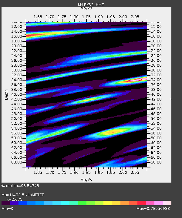
| Estimated Moho Depth: |
33.5 km |
| Estimated Crust Vp/Vs: |
2.08 |
| Assumed Crust Vp: |
6.316 km/s |
| Estimated Crust Vs: |
3.044 km/s |
| Estimated Crust Poisson's Ratio: |
0.35 |
|
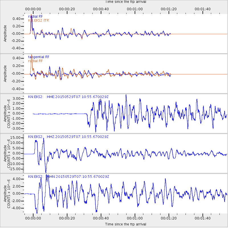
| Radial Match: |
95.54745 % |
| Radial Bump: |
400 |
| Transverse Match: |
92.21264 % |
| Transverse Bump: |
400 |
| SOD ConfigId: |
7422571 |
| Insert Time: |
2019-04-19 02:37:42.571 +0000 |
| GWidth: |
2.5 |
| Max Bumps: |
400 |
| Tol: |
0.001 |
|
Signal To Noise
| Channel | StoN | STA | LTA |
| KN:EKS2: :HHZ:20150529T07:10:55.670029Z | 166.87334 | 7.178791E-6 | 4.30194E-8 |
| KN:EKS2: :HHN:20150529T07:10:55.670029Z | 75.92146 | 2.8370864E-6 | 3.73687E-8 |
| KN:EKS2: :HHE:20150529T07:10:55.670029Z | 43.365356 | 1.3407694E-6 | 3.091798E-8 |
| Arrivals |
| Ps | 5.9 SECOND |
| PpPs | 16 SECOND |
| PsPs/PpSs | 22 SECOND |


