You are here: Home > Network List > KR - Kyrgyz Digital Network Stations List
> Station ARLS Aral, Kyrgyzstan > Earthquake Result Viewer
ARLS Aral, Kyrgyzstan - Earthquake Result Viewer
| Earthquake location: |
Alaska Peninsula |
| Earthquake latitude/longitude: |
56.7/-156.5 |
| Earthquake time(UTC): |
2015/05/29 (149) 07:00:08 GMT |
| Earthquake Depth: |
62 km |
| Earthquake Magnitude: |
6.8 MWP, 6.8 MI |
| Earthquake Catalog/Contributor: |
NEIC PDE/NEIC COMCAT |
|
| Network: |
KR Kyrgyz Digital Network |
| Station: |
ARLS Aral, Kyrgyzstan |
| Lat/Lon: |
41.87 N/74.33 E |
| Elevation: |
1526 m |
|
| Distance: |
72.9 deg |
| Az: |
322.687 deg |
| Baz: |
26.599 deg |
| Ray Param: |
0.053247895 |
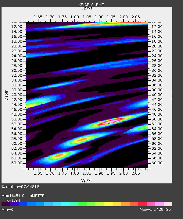
| Estimated Moho Depth: |
51.0 km |
| Estimated Crust Vp/Vs: |
1.94 |
| Assumed Crust Vp: |
6.491 km/s |
| Estimated Crust Vs: |
3.346 km/s |
| Estimated Crust Poisson's Ratio: |
0.32 |
|
| Radial Match: |
97.04818 % |
| Radial Bump: |
400 |
| Transverse Match: |
94.98726 % |
| Transverse Bump: |
400 |
| SOD ConfigId: |
7422571 |
| Insert Time: |
2019-04-19 02:37:51.287 +0000 |
| GWidth: |
2.5 |
| Max Bumps: |
400 |
| Tol: |
0.001 |
|

Signal To Noise
| Channel | StoN | STA | LTA |
| KR:ARLS: :BHZ:20150529T07:10:58.874985Z | 176.72618 | 6.434018E-6 | 3.6406703E-8 |
| KR:ARLS: :BHN:20150529T07:10:58.874985Z | 69.2449 | 2.3104594E-6 | 3.3366494E-8 |
| KR:ARLS: :BHE:20150529T07:10:58.874985Z | 41.303795 | 1.2515007E-6 | 3.0299898E-8 |
| Arrivals |
| Ps | 7.6 SECOND |
| PpPs | 22 SECOND |
| PsPs/PpSs | 30 SECOND |


