You are here: Home > Network List > KR - Kyrgyz Digital Network Stations List
> Station BTK Batken, Kyrgyzstan > Earthquake Result Viewer
BTK Batken, Kyrgyzstan - Earthquake Result Viewer
| Earthquake location: |
Alaska Peninsula |
| Earthquake latitude/longitude: |
56.7/-156.5 |
| Earthquake time(UTC): |
2015/05/29 (149) 07:00:08 GMT |
| Earthquake Depth: |
62 km |
| Earthquake Magnitude: |
6.8 MWP, 6.8 MI |
| Earthquake Catalog/Contributor: |
NEIC PDE/NEIC COMCAT |
|
| Network: |
KR Kyrgyz Digital Network |
| Station: |
BTK Batken, Kyrgyzstan |
| Lat/Lon: |
40.06 N/70.82 E |
| Elevation: |
980 m |
|
| Distance: |
75.7 deg |
| Az: |
324.361 deg |
| Baz: |
24.761 deg |
| Ray Param: |
0.051397458 |
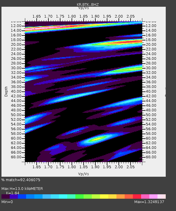
| Estimated Moho Depth: |
13.0 km |
| Estimated Crust Vp/Vs: |
1.64 |
| Assumed Crust Vp: |
6.236 km/s |
| Estimated Crust Vs: |
3.802 km/s |
| Estimated Crust Poisson's Ratio: |
0.20 |
|
| Radial Match: |
92.406075 % |
| Radial Bump: |
400 |
| Transverse Match: |
91.76176 % |
| Transverse Bump: |
400 |
| SOD ConfigId: |
7422571 |
| Insert Time: |
2019-04-19 02:37:51.456 +0000 |
| GWidth: |
2.5 |
| Max Bumps: |
400 |
| Tol: |
0.001 |
|

Signal To Noise
| Channel | StoN | STA | LTA |
| KR:BTK: :BHZ:20150529T07:11:14.949998Z | 215.24431 | 8.072208E-6 | 3.750254E-8 |
| KR:BTK: :BHN:20150529T07:11:14.949998Z | 70.213326 | 2.6621876E-6 | 3.79157E-8 |
| KR:BTK: :BHE:20150529T07:11:14.949998Z | 39.644966 | 1.0738748E-6 | 2.7087294E-8 |
| Arrivals |
| Ps | 1.4 SECOND |
| PpPs | 5.3 SECOND |
| PsPs/PpSs | 6.7 SECOND |


