You are here: Home > Network List > LD - Lamont-Doherty Cooperative Seismographic Network Stations List
> Station KSCT Kent School, Kent, Conneticut > Earthquake Result Viewer
KSCT Kent School, Kent, Conneticut - Earthquake Result Viewer
| Earthquake location: |
Alaska Peninsula |
| Earthquake latitude/longitude: |
56.7/-156.5 |
| Earthquake time(UTC): |
2015/05/29 (149) 07:00:08 GMT |
| Earthquake Depth: |
62 km |
| Earthquake Magnitude: |
6.8 MWP, 6.8 MI |
| Earthquake Catalog/Contributor: |
NEIC PDE/NEIC COMCAT |
|
| Network: |
LD Lamont-Doherty Cooperative Seismographic Network |
| Station: |
KSCT Kent School, Kent, Conneticut |
| Lat/Lon: |
41.73 N/73.48 W |
| Elevation: |
114 m |
|
| Distance: |
52.9 deg |
| Az: |
68.665 deg |
| Baz: |
316.646 deg |
| Ray Param: |
0.06628059 |
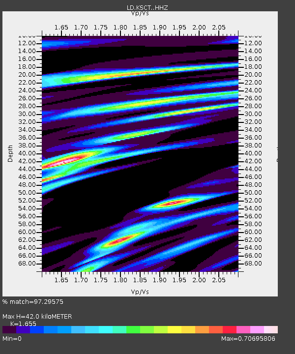
| Estimated Moho Depth: |
42.0 km |
| Estimated Crust Vp/Vs: |
1.65 |
| Assumed Crust Vp: |
6.472 km/s |
| Estimated Crust Vs: |
3.91 km/s |
| Estimated Crust Poisson's Ratio: |
0.21 |
|
| Radial Match: |
97.29575 % |
| Radial Bump: |
278 |
| Transverse Match: |
92.019035 % |
| Transverse Bump: |
400 |
| SOD ConfigId: |
7422571 |
| Insert Time: |
2019-04-19 02:38:16.227 +0000 |
| GWidth: |
2.5 |
| Max Bumps: |
400 |
| Tol: |
0.001 |
|

Signal To Noise
| Channel | StoN | STA | LTA |
| LD:KSCT: :HHZ:20150529T07:08:47.449998Z | 42.989452 | 4.206649E-6 | 9.785304E-8 |
| LD:KSCT: :HHN:20150529T07:08:47.449998Z | 23.467417 | 1.4607972E-6 | 6.224789E-8 |
| LD:KSCT: :HHE:20150529T07:08:47.449998Z | 25.79553 | 1.5267963E-6 | 5.9188405E-8 |
| Arrivals |
| Ps | 4.5 SECOND |
| PpPs | 16 SECOND |
| PsPs/PpSs | 21 SECOND |


