You are here: Home > Network List > LD - Lamont-Doherty Cooperative Seismographic Network Stations List
> Station MSNJ Montclair State University, NJ > Earthquake Result Viewer
MSNJ Montclair State University, NJ - Earthquake Result Viewer
| Earthquake location: |
Alaska Peninsula |
| Earthquake latitude/longitude: |
56.7/-156.5 |
| Earthquake time(UTC): |
2015/05/29 (149) 07:00:08 GMT |
| Earthquake Depth: |
62 km |
| Earthquake Magnitude: |
6.8 MWP, 6.8 MI |
| Earthquake Catalog/Contributor: |
NEIC PDE/NEIC COMCAT |
|
| Network: |
LD Lamont-Doherty Cooperative Seismographic Network |
| Station: |
MSNJ Montclair State University, NJ |
| Lat/Lon: |
40.88 N/74.18 W |
| Elevation: |
132 m |
|
| Distance: |
53.2 deg |
| Az: |
69.865 deg |
| Baz: |
316.909 deg |
| Ray Param: |
0.06611134 |
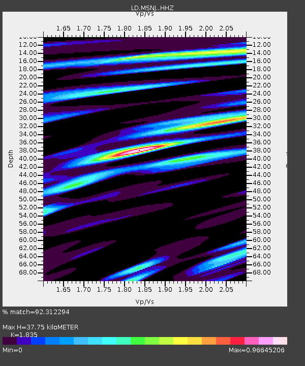
| Estimated Moho Depth: |
37.75 km |
| Estimated Crust Vp/Vs: |
1.84 |
| Assumed Crust Vp: |
6.283 km/s |
| Estimated Crust Vs: |
3.424 km/s |
| Estimated Crust Poisson's Ratio: |
0.29 |
|
| Radial Match: |
92.312294 % |
| Radial Bump: |
400 |
| Transverse Match: |
77.85659 % |
| Transverse Bump: |
400 |
| SOD ConfigId: |
7422571 |
| Insert Time: |
2019-04-19 02:38:17.937 +0000 |
| GWidth: |
2.5 |
| Max Bumps: |
400 |
| Tol: |
0.001 |
|

Signal To Noise
| Channel | StoN | STA | LTA |
| LD:MSNJ: :HHZ:20150529T07:08:49.304978Z | 26.351418 | 3.9865217E-6 | 1.5128302E-7 |
| LD:MSNJ: :HHN:20150529T07:08:49.304978Z | 13.751794 | 1.784953E-6 | 1.2979783E-7 |
| LD:MSNJ: :HHE:20150529T07:08:49.304978Z | 10.513094 | 1.2040563E-6 | 1.145292E-7 |
| Arrivals |
| Ps | 5.3 SECOND |
| PpPs | 16 SECOND |
| PsPs/PpSs | 21 SECOND |


