You are here: Home > Network List > N4 - Central and EAstern US Network Stations List
> Station N51A Ashland, OH, USA > Earthquake Result Viewer
N51A Ashland, OH, USA - Earthquake Result Viewer
| Earthquake location: |
Alaska Peninsula |
| Earthquake latitude/longitude: |
56.7/-156.5 |
| Earthquake time(UTC): |
2015/05/29 (149) 07:00:08 GMT |
| Earthquake Depth: |
62 km |
| Earthquake Magnitude: |
6.8 MWP, 6.8 MI |
| Earthquake Catalog/Contributor: |
NEIC PDE/NEIC COMCAT |
|
| Network: |
N4 Central and EAstern US Network |
| Station: |
N51A Ashland, OH, USA |
| Lat/Lon: |
40.92 N/82.37 W |
| Elevation: |
343 m |
|
| Distance: |
48.8 deg |
| Az: |
75.585 deg |
| Baz: |
315.164 deg |
| Ray Param: |
0.06892136 |
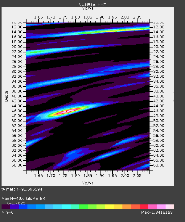
| Estimated Moho Depth: |
46.0 km |
| Estimated Crust Vp/Vs: |
1.76 |
| Assumed Crust Vp: |
6.498 km/s |
| Estimated Crust Vs: |
3.687 km/s |
| Estimated Crust Poisson's Ratio: |
0.26 |
|
| Radial Match: |
91.696594 % |
| Radial Bump: |
400 |
| Transverse Match: |
84.39516 % |
| Transverse Bump: |
400 |
| SOD ConfigId: |
7422571 |
| Insert Time: |
2019-04-19 02:39:31.016 +0000 |
| GWidth: |
2.5 |
| Max Bumps: |
400 |
| Tol: |
0.001 |
|

Signal To Noise
| Channel | StoN | STA | LTA |
| N4:N51A: :HHZ:20150529T07:08:16.87999Z | 40.02202 | 3.2360683E-6 | 8.0857205E-8 |
| N4:N51A: :HHN:20150529T07:08:16.87999Z | 15.803851 | 1.2031419E-6 | 7.6129666E-8 |
| N4:N51A: :HHE:20150529T07:08:16.87999Z | 13.925441 | 1.1121194E-6 | 7.9862424E-8 |
| Arrivals |
| Ps | 5.7 SECOND |
| PpPs | 18 SECOND |
| PsPs/PpSs | 24 SECOND |


