You are here: Home > Network List > CI - Caltech Regional Seismic Network Stations List
> Station OSI Osito Adit, California, USA > Earthquake Result Viewer
OSI Osito Adit, California, USA - Earthquake Result Viewer
| Earthquake location: |
Northern Peru |
| Earthquake latitude/longitude: |
-5.7/-76.4 |
| Earthquake time(UTC): |
2005/09/26 (269) 01:55:37 GMT |
| Earthquake Depth: |
115 km |
| Earthquake Magnitude: |
6.7 MB, 7.5 MW, 7.5 MW |
| Earthquake Catalog/Contributor: |
WHDF/NEIC |
|
| Network: |
CI Caltech Regional Seismic Network |
| Station: |
OSI Osito Adit, California, USA |
| Lat/Lon: |
34.61 N/118.72 W |
| Elevation: |
706 m |
|
| Distance: |
56.5 deg |
| Az: |
318.27 deg |
| Baz: |
126.57 deg |
| Ray Param: |
0.06371638 |
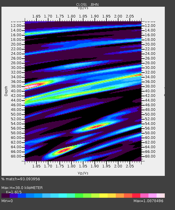
| Estimated Moho Depth: |
38.0 km |
| Estimated Crust Vp/Vs: |
1.62 |
| Assumed Crust Vp: |
6.1 km/s |
| Estimated Crust Vs: |
3.777 km/s |
| Estimated Crust Poisson's Ratio: |
0.19 |
|
| Radial Match: |
93.093956 % |
| Radial Bump: |
400 |
| Transverse Match: |
85.40466 % |
| Transverse Bump: |
400 |
| SOD ConfigId: |
2564 |
| Insert Time: |
2010-02-25 21:26:51.721 +0000 |
| GWidth: |
2.5 |
| Max Bumps: |
400 |
| Tol: |
0.001 |
|

Signal To Noise
| Channel | StoN | STA | LTA |
| CI:OSI: :BHN:20050926T02:04:37.523027Z | 18.747662 | 4.6953064E-6 | 2.5044758E-7 |
| CI:OSI: :BHE:20050926T02:04:37.523027Z | 17.082186 | 6.1072874E-6 | 3.5752376E-7 |
| CI:OSI: :BHZ:20050926T02:04:37.523027Z | 59.553795 | 1.4966032E-5 | 2.5130274E-7 |
| Arrivals |
| Ps | 4.0 SECOND |
| PpPs | 16 SECOND |
| PsPs/PpSs | 20 SECOND |


