You are here: Home > Network List > N4 - Central and EAstern US Network Stations List
> Station W57A Gilead, NC, USA > Earthquake Result Viewer
W57A Gilead, NC, USA - Earthquake Result Viewer
| Earthquake location: |
Alaska Peninsula |
| Earthquake latitude/longitude: |
56.7/-156.5 |
| Earthquake time(UTC): |
2015/05/29 (149) 07:00:08 GMT |
| Earthquake Depth: |
62 km |
| Earthquake Magnitude: |
6.8 MWP, 6.8 MI |
| Earthquake Catalog/Contributor: |
NEIC PDE/NEIC COMCAT |
|
| Network: |
N4 Central and EAstern US Network |
| Station: |
W57A Gilead, NC, USA |
| Lat/Lon: |
35.15 N/79.99 W |
| Elevation: |
85 m |
|
| Distance: |
54.3 deg |
| Az: |
78.848 deg |
| Baz: |
318.659 deg |
| Ray Param: |
0.06536638 |
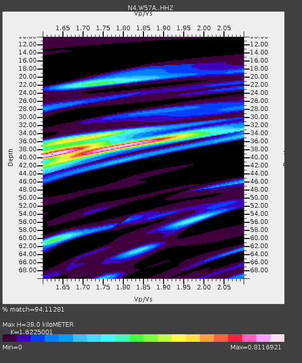
| Estimated Moho Depth: |
39.0 km |
| Estimated Crust Vp/Vs: |
1.62 |
| Assumed Crust Vp: |
6.565 km/s |
| Estimated Crust Vs: |
4.046 km/s |
| Estimated Crust Poisson's Ratio: |
0.19 |
|
| Radial Match: |
94.11281 % |
| Radial Bump: |
283 |
| Transverse Match: |
87.023 % |
| Transverse Bump: |
400 |
| SOD ConfigId: |
7422571 |
| Insert Time: |
2019-04-19 02:40:13.330 +0000 |
| GWidth: |
2.5 |
| Max Bumps: |
400 |
| Tol: |
0.001 |
|

Signal To Noise
| Channel | StoN | STA | LTA |
| N4:W57A: :HHZ:20150529T07:08:57.730027Z | 42.920025 | 2.9363687E-6 | 6.8414884E-8 |
| N4:W57A: :HHN:20150529T07:08:57.730027Z | 22.488745 | 1.4981125E-6 | 6.66161E-8 |
| N4:W57A: :HHE:20150529T07:08:57.730027Z | 25.45647 | 1.3798398E-6 | 5.420389E-8 |
| Arrivals |
| Ps | 3.9 SECOND |
| PpPs | 15 SECOND |
| PsPs/PpSs | 19 SECOND |


