You are here: Home > Network List > N4 - Central and EAstern US Network Stations List
> Station X58A Rowland, NC, USA > Earthquake Result Viewer
X58A Rowland, NC, USA - Earthquake Result Viewer
| Earthquake location: |
Alaska Peninsula |
| Earthquake latitude/longitude: |
56.7/-156.5 |
| Earthquake time(UTC): |
2015/05/29 (149) 07:00:08 GMT |
| Earthquake Depth: |
62 km |
| Earthquake Magnitude: |
6.8 MWP, 6.8 MI |
| Earthquake Catalog/Contributor: |
NEIC PDE/NEIC COMCAT |
|
| Network: |
N4 Central and EAstern US Network |
| Station: |
X58A Rowland, NC, USA |
| Lat/Lon: |
34.55 N/79.34 W |
| Elevation: |
45 m |
|
| Distance: |
55.1 deg |
| Az: |
78.833 deg |
| Baz: |
319.022 deg |
| Ray Param: |
0.06483799 |
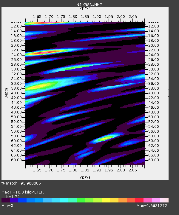
| Estimated Moho Depth: |
10.0 km |
| Estimated Crust Vp/Vs: |
1.74 |
| Assumed Crust Vp: |
6.565 km/s |
| Estimated Crust Vs: |
3.773 km/s |
| Estimated Crust Poisson's Ratio: |
0.25 |
|
| Radial Match: |
93.900085 % |
| Radial Bump: |
400 |
| Transverse Match: |
78.24064 % |
| Transverse Bump: |
400 |
| SOD ConfigId: |
7422571 |
| Insert Time: |
2019-04-19 02:40:15.600 +0000 |
| GWidth: |
2.5 |
| Max Bumps: |
400 |
| Tol: |
0.001 |
|

Signal To Noise
| Channel | StoN | STA | LTA |
| N4:X58A: :HHZ:20150529T07:09:03.520005Z | 25.847204 | 3.4203272E-6 | 1.3232871E-7 |
| N4:X58A: :HHN:20150529T07:09:03.520005Z | 13.463816 | 1.5585563E-6 | 1.1575889E-7 |
| N4:X58A: :HHE:20150529T07:09:03.520005Z | 13.461713 | 1.5332241E-6 | 1.1389518E-7 |
| Arrivals |
| Ps | 1.2 SECOND |
| PpPs | 3.9 SECOND |
| PsPs/PpSs | 5.1 SECOND |


