You are here: Home > Network List > NX - Nanometrics Research Network Stations List
> Station STN01 Seismic station 01 > Earthquake Result Viewer
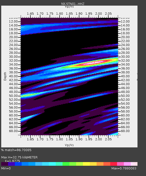
STN01 Seismic station 01 - Earthquake Result Viewer
| Earthquake location: |
Alaska Peninsula |
| Earthquake latitude/longitude: |
56.7/-156.5 |
| Earthquake time(UTC): |
2015/05/29 (149) 07:00:08 GMT |
| Earthquake Depth: |
62 km |
| Earthquake Magnitude: |
6.8 MWP, 6.8 MI |
| Earthquake Catalog/Contributor: |
NEIC PDE/NEIC COMCAT |
|
| Network: |
NX Nanometrics Research Network |
| Station: |
STN01 Seismic station 01 |
| Lat/Lon: |
35.83 N/97.65 W |
| Elevation: |
316 m |
|
| Distance: |
44.1 deg |
| Az: |
92.37 deg |
| Baz: |
317.286 deg |
| Ray Param: |
0.07193349 |
| Estimated Moho Depth: |
32.75 km |
| Estimated Crust Vp/Vs: |
1.98 |
| Assumed Crust Vp: |
6.426 km/s |
| Estimated Crust Vs: |
3.25 km/s |
| Estimated Crust Poisson's Ratio: |
0.33 |
|
| Radial Match: |
96.70085 % |
| Radial Bump: |
272 |
| Transverse Match: |
82.5455 % |
| Transverse Bump: |
400 |
| SOD ConfigId: |
7422571 |
| Insert Time: |
2019-04-19 02:41:01.444 +0000 |
| GWidth: |
2.5 |
| Max Bumps: |
400 |
| Tol: |
0.001 |
|

Signal To Noise
| Channel | StoN | STA | LTA |
| NX:STN01: :HHZ:20150529T07:07:40.199998Z | 70.7575 | 5.4799093E-6 | 7.744634E-8 |
| NX:STN01: :HH1:20150529T07:07:40.199998Z | 35.19882 | 3.1702748E-6 | 9.006765E-8 |
| NX:STN01: :HH2:20150529T07:07:40.199998Z | 16.889767 | 1.1821996E-6 | 6.9995025E-8 |
| Arrivals |
| Ps | 5.3 SECOND |
| PpPs | 14 SECOND |
| PsPs/PpSs | 20 SECOND |


