You are here: Home > Network List > IU - Global Seismograph Network (GSN - IRIS/USGS) Stations List
> Station XMAS Kiritimati Island, Republic of Kiribati > Earthquake Result Viewer
XMAS Kiritimati Island, Republic of Kiribati - Earthquake Result Viewer
| Earthquake location: |
Jujuy Province, Argentina |
| Earthquake latitude/longitude: |
-23.5/-66.5 |
| Earthquake time(UTC): |
2000/05/12 (133) 18:43:18 GMT |
| Earthquake Depth: |
225 km |
| Earthquake Magnitude: |
6.2 MB, 7.2 MW, 7.1 MW |
| Earthquake Catalog/Contributor: |
WHDF/NEIC |
|
| Network: |
IU Global Seismograph Network (GSN - IRIS/USGS) |
| Station: |
XMAS Kiritimati Island, Republic of Kiribati |
| Lat/Lon: |
2.04 N/157.45 W |
| Elevation: |
2.0 m |
|
| Distance: |
91.7 deg |
| Az: |
271.47 deg |
| Baz: |
113.368 deg |
| Ray Param: |
0.041461203 |
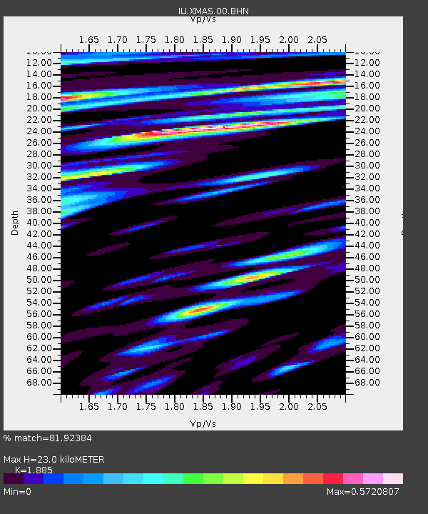
| Estimated Moho Depth: |
23.0 km |
| Estimated Crust Vp/Vs: |
1.88 |
| Assumed Crust Vp: |
4.802 km/s |
| Estimated Crust Vs: |
2.547 km/s |
| Estimated Crust Poisson's Ratio: |
0.30 |
|
| Radial Match: |
81.92384 % |
| Radial Bump: |
400 |
| Transverse Match: |
54.08044 % |
| Transverse Bump: |
400 |
| SOD ConfigId: |
3744 |
| Insert Time: |
2010-03-02 15:49:14.443 +0000 |
| GWidth: |
2.5 |
| Max Bumps: |
400 |
| Tol: |
0.001 |
|

Signal To Noise
| Channel | StoN | STA | LTA |
| IU:XMAS:00:BHN:20000512T18:55:28.560002Z | 1.5707868 | 1.0931158E-6 | 6.9590334E-7 |
| IU:XMAS:00:BHE:20000512T18:55:28.560002Z | 0.6786222 | 6.22417E-7 | 9.171775E-7 |
| IU:XMAS:00:BHZ:20000512T18:55:28.560002Z | 1.2346011 | 1.0802332E-6 | 8.7496534E-7 |
| Arrivals |
| Ps | 4.3 SECOND |
| PpPs | 14 SECOND |
| PsPs/PpSs | 18 SECOND |


