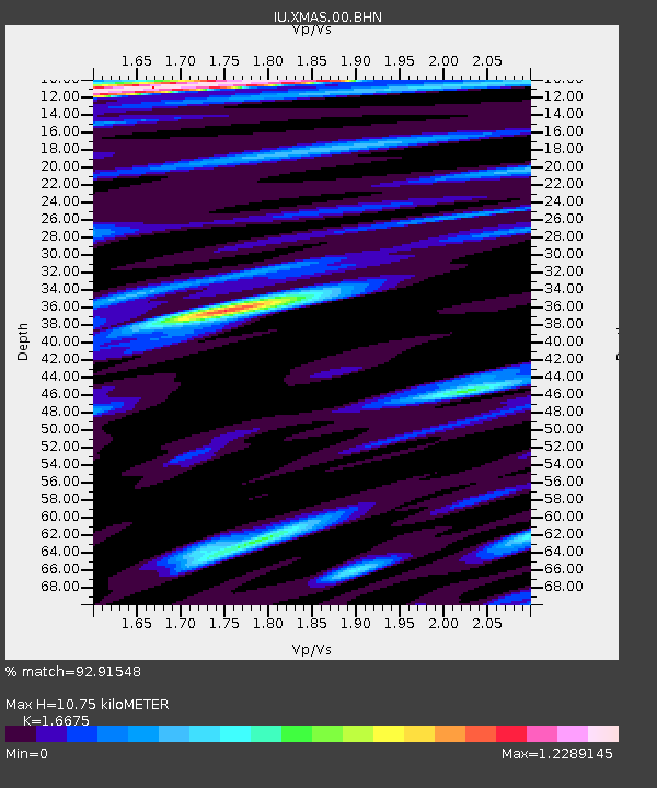
XMAS Kiritimati Island, Republic of Kiribati - Earthquake Result Viewer
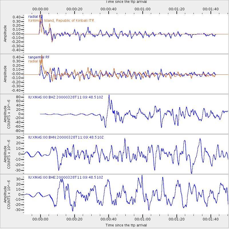
Earthquake location: Volcano Islands, Japan Region
Earthquake latitude/longitude: 22.3/143.7
Earthquake time(UTC): 2000/03/28 (088) 11:00:22 GMT
Earthquake Depth: 126 km
Earthquake Magnitude: 6.8 MB, 7.6 MS, 7.6 MW, 7.6 MW
Earthquake Catalog/Contributor: WHDF/NEIC
Network: IU Global Seismograph Network (GSN - IRIS/USGS)
Station: XMAS Kiritimati Island, Republic of Kiribati
Lat/Lon: 2.04 N/157.45 W
Elevation: 2.0 m
Distance: 60.5 deg
Az: 100.772 deg
Baz: 294.48 deg
Ray Param: 0.06111084
Estimated Moho Depth: 10.75 km
Estimated Crust Vp/Vs: 1.67
Assumed Crust Vp: 4.802 km/s
Estimated Crust Vs: 2.88 km/s
Estimated Crust Poisson's Ratio: 0.22
Radial Match: 92.91548 %
Radial Bump: 400
Transverse Match: 79.65999 %
Transverse Bump: 400
SOD ConfigId: 3744
Insert Time: 2010-03-02 15:49:16.340 +0000
GWidth: 2.5
Max Bumps: 400
Tol: 0.001

Signal To Noise

ChannelStoNSTALTA
IU:XMAS:00:BHN:20000328T11:09:48.510Z0.76011151.7994515E-62.367352E-6
IU:XMAS:00:BHE:20000328T11:09:48.510Z1.72892052.6502662E-61.5329024E-6
IU:XMAS:00:BHZ:20000328T11:09:48.510Z1.63420863.1057248E-61.9004458E-6
Arrivals
Ps1.5 SECOND
PpPs5.8 SECOND
PsPs/PpSs7.3 SECOND