You are here: Home > Network List > IU - Global Seismograph Network (GSN - IRIS/USGS) Stations List
> Station XMAS Kiritimati Island, Republic of Kiribati > Earthquake Result Viewer
XMAS Kiritimati Island, Republic of Kiribati - Earthquake Result Viewer
| Earthquake location: |
Kermadec Islands, New Zealand |
| Earthquake latitude/longitude: |
-29.7/-178.6 |
| Earthquake time(UTC): |
2001/06/03 (154) 02:41:57 GMT |
| Earthquake Depth: |
178 km |
| Earthquake Magnitude: |
6.8 MB, 7.2 MW, 7.1 MW |
| Earthquake Catalog/Contributor: |
WHDF/NEIC |
|
| Network: |
IU Global Seismograph Network (GSN - IRIS/USGS) |
| Station: |
XMAS Kiritimati Island, Republic of Kiribati |
| Lat/Lon: |
2.04 N/157.45 W |
| Elevation: |
2.0 m |
|
| Distance: |
37.5 deg |
| Az: |
36.412 deg |
| Baz: |
211.128 deg |
| Ray Param: |
0.075447045 |
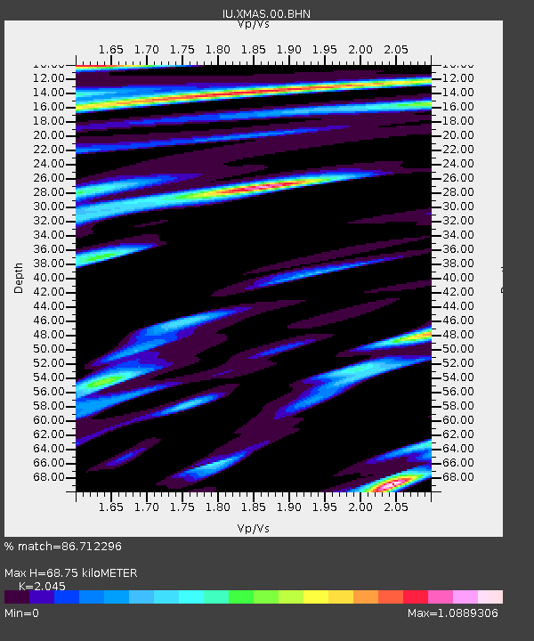
| Estimated Moho Depth: |
68.75 km |
| Estimated Crust Vp/Vs: |
2.05 |
| Assumed Crust Vp: |
4.802 km/s |
| Estimated Crust Vs: |
2.348 km/s |
| Estimated Crust Poisson's Ratio: |
0.34 |
|
| Radial Match: |
86.712296 % |
| Radial Bump: |
400 |
| Transverse Match: |
87.020546 % |
| Transverse Bump: |
400 |
| SOD ConfigId: |
4714 |
| Insert Time: |
2010-03-02 15:49:20.687 +0000 |
| GWidth: |
2.5 |
| Max Bumps: |
400 |
| Tol: |
0.001 |
|

Signal To Noise
| Channel | StoN | STA | LTA |
| IU:XMAS:00:BHN:20010603T02:48:23.148007Z | 3.9280937 | 2.6709445E-6 | 6.799595E-7 |
| IU:XMAS:00:BHE:20010603T02:48:23.148007Z | 2.2936215 | 1.3240839E-6 | 5.772896E-7 |
| IU:XMAS:00:BHZ:20010603T02:48:23.148007Z | 9.242558 | 6.8558493E-6 | 7.417697E-7 |
| Arrivals |
| Ps | 15 SECOND |
| PpPs | 42 SECOND |
| PsPs/PpSs | 58 SECOND |


