You are here: Home > Network List > IU - Global Seismograph Network (GSN - IRIS/USGS) Stations List
> Station XMAS Kiritimati Island, Republic of Kiribati > Earthquake Result Viewer
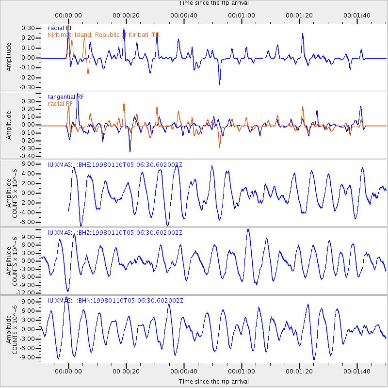
XMAS Kiritimati Island, Republic of Kiribati - Earthquake Result Viewer
*The percent match for this event was below the threshold and hence no stack was calculated.
| Earthquake location: |
Central Peru |
| Earthquake latitude/longitude: |
-12.0/-72.1 |
| Earthquake time(UTC): |
1998/01/10 (010) 04:54:25 GMT |
| Earthquake Depth: |
33 km |
| Earthquake Magnitude: |
5.7 MB, 5.9 MS, 6.4 UNKNOWN, 6.2 MW |
| Earthquake Catalog/Contributor: |
WHDF/NEIC |
|
| Network: |
IU Global Seismograph Network (GSN - IRIS/USGS) |
| Station: |
XMAS Kiritimati Island, Republic of Kiribati |
| Lat/Lon: |
2.04 N/157.45 W |
| Elevation: |
2.0 m |
|
| Distance: |
85.9 deg |
| Az: |
272.952 deg |
| Baz: |
102.139 deg |
| Ray Param: |
$rayparam |
*The percent match for this event was below the threshold and hence was not used in the summary stack. |
|
| Radial Match: |
61.45062 % |
| Radial Bump: |
400 |
| Transverse Match: |
63.02584 % |
| Transverse Bump: |
330 |
| SOD ConfigId: |
4480 |
| Insert Time: |
2010-03-02 15:49:39.294 +0000 |
| GWidth: |
2.5 |
| Max Bumps: |
400 |
| Tol: |
0.001 |
|
Signal To Noise
| Channel | StoN | STA | LTA |
| IU:XMAS: :BHZ:19980110T05:06:30.602002Z | 1.7409155 | 6.9273406E-6 | 3.9791366E-6 |
| IU:XMAS: :BHN:19980110T05:06:30.602002Z | 1.7921884 | 6.43323E-6 | 3.5895946E-6 |
| IU:XMAS: :BHE:19980110T05:06:30.602002Z | 1.5043055 | 4.043972E-6 | 2.688265E-6 |
| Arrivals |
| Ps | |
| PpPs | |
| PsPs/PpSs | |


